
So I snagged a couple permits: one for a 4-night loop through the Clark Range in Yosemite National Park, and another for a 1-night out-and-back in the Ansel Adams Wilderness near Mammoth. The Clark Range is a north-south trending spine of peaks ~11,500 ft in the southwest corner of Yosemite National Park, and the Ritter Range is an exceptionally beautiful set of volcanic peaks to the west of Yosemite, near the town of Mammoth, CA. I had passed through the area on the JMT (Garnet Lake, Banner Peak, and Thousand Island Lake) and was blown away by the volcanic terrain that is distinct from just about every other corner of the High Sierra.
Part I – Clark Range, Yosemite National Park (65 miles)
Day 1, Sunday September 29: San Gregorio to Mt. Starr King (6 miles)
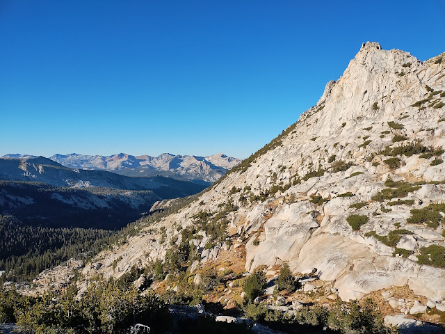
I leave home around 10am, skirt across the Central Valley to Sonora, and then start the winding ascent and descent into Yosemite Valley. Although I cruised through parts of the park at the tail end of my JMT adventure (Tuolumne Meadows specifically), I had never been to the famed Yosemite Valley. When I arrive, it is pretty overwhelming, with so many people, cars, hotels, restaurants etc., so I decide to change my permit to today (Sunday) instead of the next day (Monday). After a few heavily-buttered oat bran muffins, I climb 2-3 miles through the Merced River Gorge toward Nevada Falls on one of the most popular trails in the park, and then turn south and climb over to the Illilouette Basin, where I don’t see another person for the rest of the day, and the “Yosemite vibes” (i.e. ice-polished granite walls and domes) start to peter out.
After descending briefly into a stand of spooky pines, I hear a crash nearby and watch a black bear run off downslope / westward toward Illilouette Creek. I walk for another few miles along the western side of Mt. Starr King, the last of the Yosemite-style domes that I will see for the next couple of days. I pass dry creek after dry creek, and then finally hear a trickle of water around dusk. I fill up my water bottles, cross the small creek, and then climb 100 yards up the slope and set up camp. I don’t take any pictures because I am saving my phone battery for the higher-elevation passes of the coming days.
Day 2, Monday September 30: Mt. Starr King to Unnamed Lake (17 miles)
Continuing on the trail, I immediately stumble on another black bear that goes crashing off into the brush. Water continues to be sparse, but there are just enough flowing streams to keep my water supply steady. I pass a set of four backpackers going the opposite direction, who tell me I’m the first person they’ve seen in days. I spend most of the morning steadily climbing the Illilouette drainage to the Merced Pass junction, where I turn northeast and start ascending toward Ottoway Lake and Red Peak Pass. Along the way, I leapfrog with two National Park Service trail maintenance guys and their mule team. They spend 8 days on the trail, moving the pack train steadily along and using chainsaws to remove down trees from the trail and thin the saplings that are springing up just next to the trail. One of the guys is about my age, thin, wearing a cowboy hat. The other is just about the most quintessential mountain man I’ve ever seen. He is probably in his late sixties, with a thick mustache that hangs down on the sides of his mouth. I’m pretty sure this guy was the inspiration for Yosemite Sam.
“Wow, great mustache. You’ve got the prospector look goin.”
“Oh yeah, I get that a lot. I am a fan.”
A few minutes later, I pass his younger friend on the trail.
“Wow, your friend really transported me back in time.”
“Oh yeah that guy’s a legend, he’s been out here doing this same job for over 30 years.”
These guys are the last people I see for the next 24 hours. By the time I get to Ottoway Lake, it is mid-afternoon and I’m pretty tired and hot, so when I stumble on the perfect rock jumping spot, I ditch all my gear, strip down, and jump in. I’m dry within a few minutes due to the aridity and hot sun. It’s a bit too early to camp, and I have another few miles in me, but I’m a little bummed that I won’t be camping at this ideal spot.
Continuing past Ottoway Lake, I ascend Red Peak Pass, where I climb a small spire and get good views of the drainage I just ascended to the southwest, and the Merced River Gorge, Cathedral Range, and Ritter Range to the east. It is unfortunate that there are no East-West trails between the Clark Range and the Ritter Range – it is only ~11 miles between where I am standing and Mt. Ritter as the crow flies, but would require ~30 miles of walking to make the connection. Ascending steep mountain passes is my favorite aspect of these adventures – it’s really what it’s all about. The long periods spent walking along creeks below treeline, sleeping on the ground etc. really just lay the foundation for the challenges and joys of ascending above treeline with constantly-changing views of the surrounding mountains and valleys. Alpine lakes are a close second.
On the far side of the pass, I descend through rusty red talus slopes before pausing to eat my refried bean dinner next to a small alpine lake. The sun has already dropped below the steep horizon to the west by the time I finish dinner, so I continue walking another mile or so to another unnamed lake, where I set up camp.
 |
| Ottoway Lake |
 |
| Ottoway Lake |
 |
| Ascending Red Peak Pass, Merced Peak in the background |
 |
| Ascending Red Peak Pass, looking back at Ottoway Lake |
 |
| Upper Ottoway Lake, Merced Peak in the background |
 |
| Ascending Red Peak Pass |
 |
| From Red Peak Pass, looking back at Merced Peak and Upper Ottoway Lake |
 |
Looking East towards the Cathedral and Ritter Ranges;
Banner Peak, Mt. Ritter, and the Minarets center right |
 |
| Looking northeast towards the Cathedral Range and the Merced River Gorge |
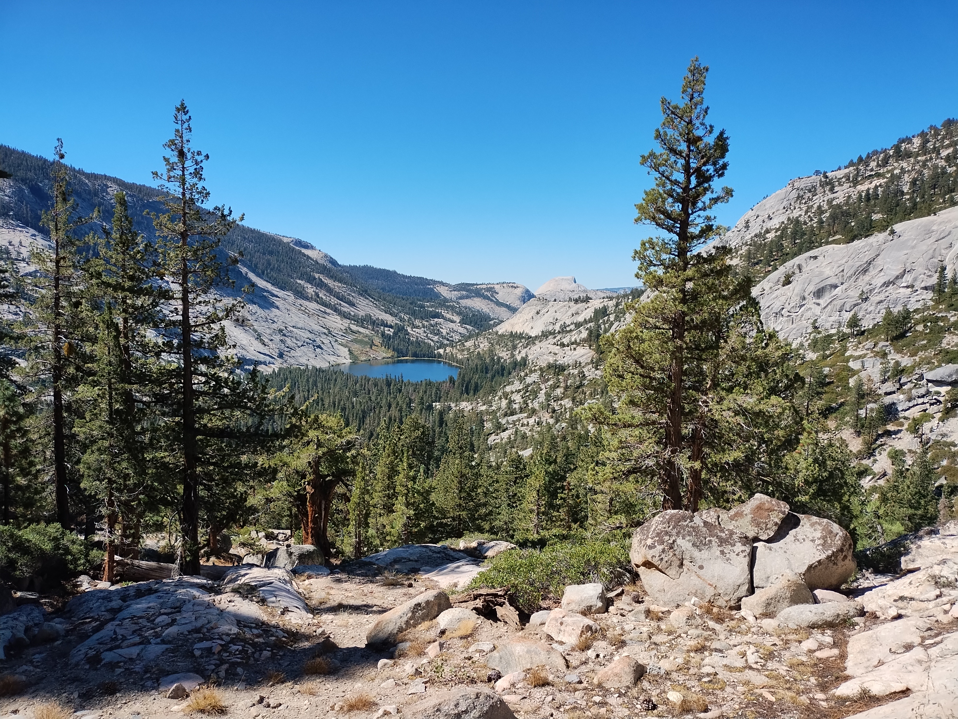
Day 3, Tuesday, October 1: Unnamed Lake to Lewis Creek and the Merced High Route (18 miles)
In the morning, the lake is perfectly still and mirrors the surrounding rocks and trees. I take a minute to enjoy while I sip on my protein beverage, before continuing on the trail. I descend and ascend through two drainages before reaching the Triple Peak Fork of the Merced River. Here I have two options: (1) continue along the Merced River, slowly descending all the way to Merced Lake (Merced River Trail) or (2) climb up onto the shoulder of the Merced River Gorge and continue roughly the same direction as the Merced River Trail, but ~1000 feet higher (the Merced High Route). Obviously, I choose the High Route. This has the benefit of occasional great views, but the major downside of walking perpendicular to the creek drainages. This means that most of the day is spent descending 200-600 feet to the creek, and then ascending 200-600 ft up to the next divide, before doing it all over again. This repeats about eight times – I’ve included a snapshot of the elevation profile below just to give you a flavor of this pattern. The JMT is similar, but involves much more extreme changes: usually 2000-3000 foot ascents / descents. The best part of the Merced High Route is crossing the Lyell Fork of the Merced River, where the Yosemite vibes resume: the Lyell Fork tumbles down to the main stem through a wide polished granite half-bowl.
 |
| Elevation Profile along Route |
The Merced High Route concludes at Lewis Creek, where I have a choice to make. I can either turn left / West towards Merced Lake and complete my overall loop in a shorter distance, or turn right / East, tack on another 8 miles to the loop, and ascend Vogelsang Pass. The ups and downs of the Merced High Route had me feeling pretty exhausted throughout most of the afternoon, but for whatever reason, when I arrive at Lewis Creek I get a burst of energy and make a quick decision to go the long route and begin ascending Lewis Creek. I walk another three miles, before setting up camp on an island between two branches of Lewis Creek, where I eat my refried bean dinner and go to sleep.
 |
| Unnamed Lake below Red Peak |
 |
| Unnamed Lake below Red Peak |
 |
| Alpine Landscape below Triple Divide Peak |
 |
Looking Northwest at the Merced River Gorge;
Lyell Fork of the Merced at right |
 |
| Looking West at the Merced River Gorge and the Clark Range from just above Lyell Fork |
 |
Looking West-Northwest at the Merced River Gorge and the Clark Range from just above Lyell Fork
|
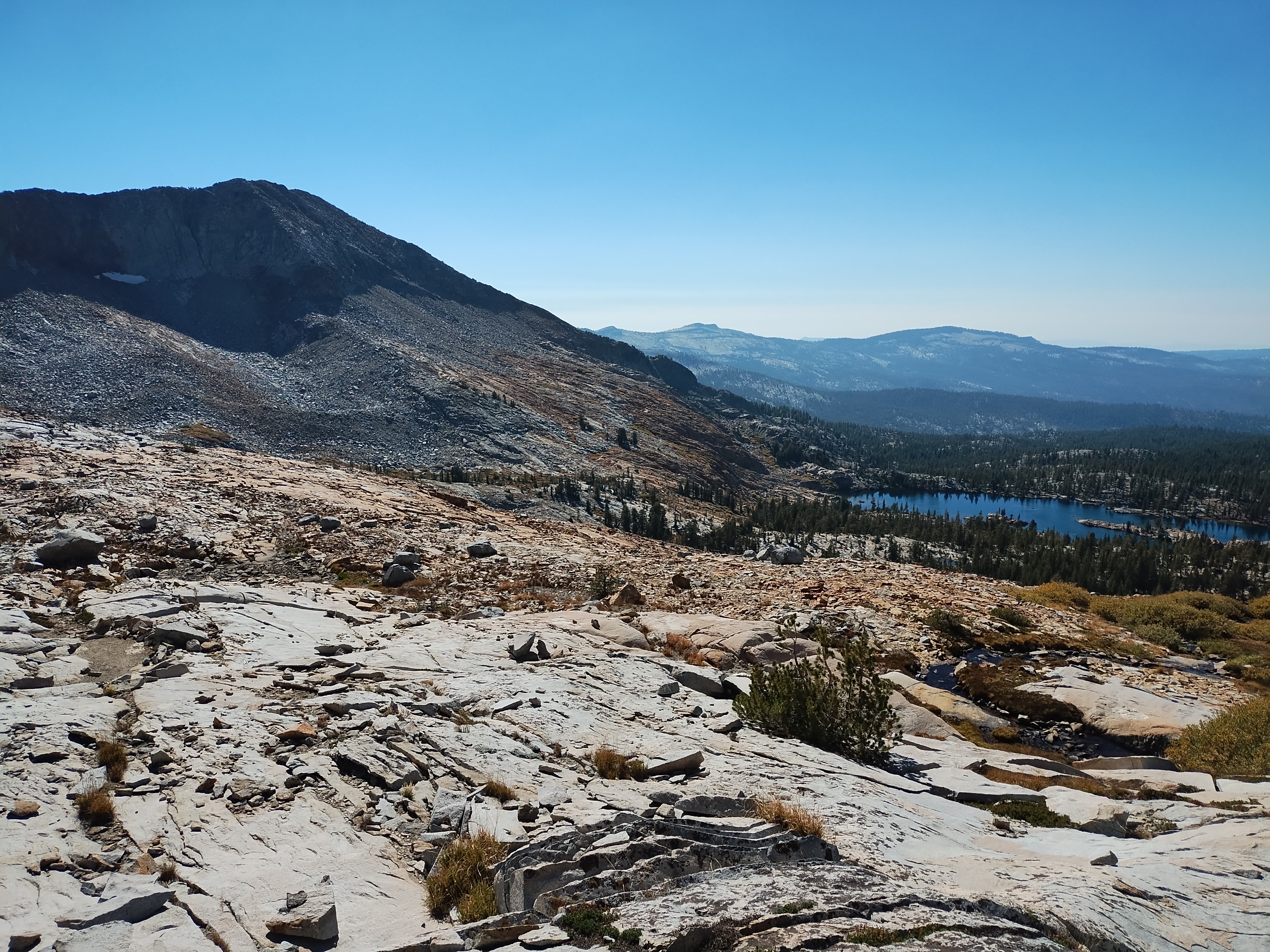
Day 4, Wednesday, October 2: Lewis Creek to Little Yosemite Valley (19 miles)
I make quick work of Vogelsang Pass, take a break at Vogelsang Lake, and then begin descending the Fletcher Creek drainage, where the Yosemite vibes are strong. I walk through wide, flat meadows bounded by elongated granite domes that remind me of the droid ships from the Trade Federation invasion of Naboo in Star Wars Episode 1. It is a similar landscape to Tuolumne Meadows, where I ended my JMT trek a few years earlier. Following the meadows, the descent becomes much steeper and I walk down rock staircases along polished granite washes to Merced Lake. I had thought of stopping to camp and swim at Merced Lake, but the edge of the lake is pretty muddy and grassy all around, and it is still early when I arrive, so I decide to continue. The route then proceeds through one canyon after another: a steep descent through a narrow gorge, followed by a flat walk along the stream. When I get to Lost Canyon, it is about time to stop for the day, and there is a really nice granite waterslide leading into a deep pool, ideal for swimming. There are a couple folks swimming there, so I apologize for disturbing their solitude (they are happy to share) and then jump in.
Afterward, I find a small gravel patch near the pool, set up camp, and cook my refried black bean dinner. When the other folks are on their way out, they encounter a giant rattlesnake about as thick as my upper arm. It quickly slithers into a bush, but ~10 minutes after they leave, I go back to the spot and find that the snake has re-emerged. I stare at it for a while, realizing that I am not ready to share this spot with such a dangerous creature. Looking around, I am filled with the sense that the surrounding terrain – bowling ball sized cobbles, recently burned trees, and low-lying shrubs – is ideal rattlesnake territory. I decide not to take any chances, pack up my tent, and then continue down the trail another two miles to Little Yosemite Valley, a high-density backpackers camp that serves as a basecamp for popular routes like Half Dome. I am glad to be far from the snake – beautiful creatures, but not ideal neighbors.
 |
| Ascending Vogelsang Pass, looking south to Parsons Peak, Simmons Peak, and Mt. Florence |
 |
| Ascending Vogelsang Pass, looking West towards the Clark Range |
 |
Ascending Vogelsang Pass, looking south to Parsons Peak, Simmons Peak, and Mt. Florence
|
 |
| Vogelsang Pass and Vogelsang Lake |
 |
| Looking North at Choo-Choo Mountain from Vogelsang Pass |
 |
| Vogelsang Lake |
 |
| Meadows along Fletcher Creek |
 |
| Elongated Granite Domes |
 |
| Granite Wash Descending towards Merced Lake |
 |
| Granite Dome Descending towards Merced Lake |
 |
| Merced Lake; Half Dome in the background |
 |
| Merced Lake |
Day 5, Thursday, October 3: Little Yosemite Valley to Tioga Pass (5 miles)
In the morning, I descend through the shade cast by the steep canyon walls past Nevada Falls and along the Merced River to Happy Isles trailhead in Yosemite Valley, greeting the morning ascenders along the way. I spend the rest of the day enjoying all that Yosemite Valley has to offer: I buy a $5 shower at Curry Village (so fancy!), get a $12 burger at the Village Grill, enjoy free Wi-Fi at Degnan’s Deli, and ride the free shuttle around the park including a stop at El Capitan to watch the big wall climbers. It’s honestly a bit shocking how developed Yosemite Valley is, including many restaurants, hotels, even a pool, but it is nice to have access to showers, reasonably priced hot food, and free wi-fi at the end of a backpacking trip. I had initially planned on camping in my truck that night, but a friendly ranger at the Wilderness Center tells me that is not allowed, so I decide to leave the park for more peace of mind. I drive a couple hours up Tioga Road through Tuolumne Meadows to the crest of Tioga Pass, and then park at a pullout just outside of the park boundary. There are probably 8-10 vans parked there already – dirtbag city! I enjoy some mashed potatoes on the tailgate before crawling into the back of my truck and reading John Steinbeck’s Travels with Charley before going to sleep.
 |
| Liberty Cap and Nevada Falls from Clark Point |
Part II – Ritter Range, Ansel Adams Wilderness (14 miles)
Day 6, Friday, October 4: Mammoth Lakes (0 miles)
In the morning, I descend the eastern side of Tioga Pass toward Mono Lake, and then take the scenic route to Mammoth Lakes. There, I scope out the breakfast options and eventually end up at a Latin Market that has good reviews and low prices. I discover that everything comes in a styrofoam container, so I give up on that, head to Von’s, buy a pound of burger, and fry it up on my tailgate in the parking lot. I spend the rest of the morning and early afternoon charging my phone and reading at the Mammoth library, before going out to explore the Mammoth Museum. This turns out to be closed, so I proceed to some lakes that are just outside of town. I sit on a chair reading my book next to one of the lakes before it starts getting cold, windy, and drizzly in the late afternoon, and then head to Salsa’s Taqueria in town. This is the best meal out of the entire trip: I get a California Burrito and a Quesabirria taco, and drench both in the hot red salsa from the free salsa bar. I don’t eat a lot of burritos due to the tortilla aspect (I’d be really into a large corn tortilla if that existed), but when there is salsa in sufficient quantity and quality (ideally, salsa bar or large squeeze bottles available at every table), I really enjoy dousing each bite of the burrito as I go. Afterward I make my way up Minaret Road to “Earthquake Fault”, a small trailhead / park with a visible earthquake fault zone, check out the fault, read my book, and then go to sleep in the truck.
 |
| Earthquake Fault Zone |
 |
| Earthquake Fault Zone |
Day 7, Saturday, October 5: Agnew Meadows to Ediza Lake (7 miles)
For my final adventure, I have to pay close attention to the closures on Red’s Meadow Road that lead to the trailhead. This road is under major construction, and is closed except for a short window between Saturday at 7am and Sunday at 11pm. I arrive at the closure around 6:45am, where three cars are already parked. As I wait, another 20 or so cars start to line up behind me. Finally, at 7am, the rangers open the gate, and let us all proceed down the one-lane road. After a short drive on the narrow gravel road, I make it to Agnew Meadows trailhead and start walking.
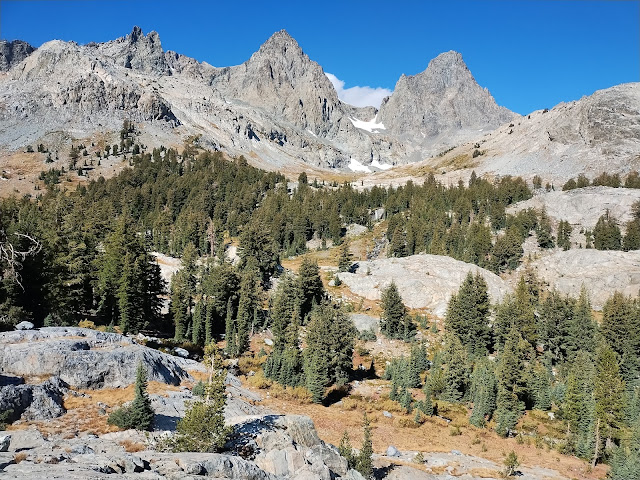
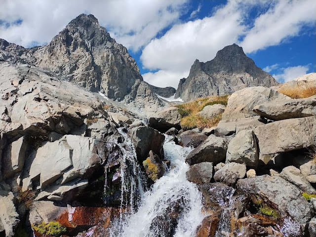
I walk along the Middle Fork of the San Joaquin river, turn west up Shadow Creek to Shadow Lake, and then continue along Shadow Creek to Ediza Lake. I overlap with the JMT for a couple miles, glad that I have returned to enjoy this area a bit more than I could at that time. The view at Ediza Lake is incredible, with Mt. Ritter and Banner Peak to the north, and the Minarets to the south. I continue to the far side of the lake, climb up to a rock outcrop, and then set up camp on top overlooking the lake. It is only about 10am, so I have the whole day ahead of me to enjoy the area without my pack. I start by climbing a primitive trail following a stream up to the base of Mt. Ritter and Banner Peak. I do a lap around the area, climbing up onto a pile of rocks overlooking Ediza Lake to the south, the Nydiver Lakes to the northeast, and the peaks to the west. I descend once again, and then follow the main trail up to Iceberg Lake, walk along talus slopes up to Cecile Lake, peer out onto Minaret Lake, and then turn around and head back to camp, where I read, eat refried black beans, and go to sleep.
 |
| Fall Colors along the Middle Fork of the San Joaquin |
 |
| Volcanic Rocks |
 |
| Looking South at Volcanic Ridge reflected in Shadow Lake |
 |
| Looking West at Banner Peak, Mt. Ritter, and the edge of the Minarets reflected in Shadow Lake |
 |
| Looking South at Volcanic Ridge and Shadow Creek |
 |
| Looking West at Mt. Ritter (left) and Banner Peak (right) reflected in Ediza Lake |
 |
| Looking Southwest at the Minarets above Ediza Lake |
 |
| Looking Northwest at Mt. Ritter (left) and Banner Peak (right) from my campsite |
 |
| Campsite with the Minarets in the background, Looking Southwest |
 |
| Looking East at Lake Ediza from my campsite |
 |
| Looking West at Mt. Ritter (left) and Banner Peak (right) |
 |
| Looking South at the Minarets |
 |
| Looking Southeast at Volcanic Ridge and Ediza Lake |
 |
| Looking Northeast at Nydiver Lakes |
 |
| Looking Southwest at the Minarets |
 |
| Looking Southeast at Volcanic Ridge |
 |
| Drainage from Mt. Ritter and Banner Peak |
 |
| Looking South at Iceberg Lake and the Minarets |
 |
| Looking North at Iceberg Lake |
 |
| Looking West at a section of the Minarets |
 |
| Looking Southeast at Minaret Lake; Mammoth Mountain in the background |
 |
| Looking West across Cecile Lake to the Minarets |
 |
| Sunset on Volcanic Ridge, Looking South from Campsite |
Day 8, Sunday, October 6: Ediza Lake to Everline Resort (7 miles)
In the morning, I pack up and bid farewell to Ediza Lake. I’m not willing to putz around for an hour while the sun fully rises on the lake, so I take a couple shadowed shots, and then make my way to the trailhead. The return trip on the one-lane road is challenging, with many day-trippers driving in the opposite direction, one of us needing to yield each time depending on the width of the road on either side. Finally, I make it back to the pavement, say goodbye to Mammoth, and then continue north along Highway 395 that follows the eastern side of the Sierra through the towns of Lee Vining and Bridgeport, and then crosses into Nevada at Topaz. In Nevada, I buy some cheap gas, and then ascend into the mountains once again to South Lake Tahoe, where I eat at Chipotle, get a cheap haircut, and go on a quest for a nail-clipper (7-Eleven has them for $2 whereas CVS charges $10! For a nail clipper!). I cruise along the western side of the lake until I reach Everline Resort, where the groundwater conference is being held. The parking situation is a bit confusing: you can either use valet parking or self-park a quarter mile away. But for self-park, they encourage you to drop off your luggage in the entryway first. I am not fully prepared for this, so I spend a good ten minutes running around, digging in the back of my mud-covered truck, pulling out various bins, shoving pairs of shoes and water bottles and sunglasses in various pockets, and otherwise pull together the items I will need for the conference, all while the bellhops look on. Finally I get it all together, go and park, and then make my way to the room, where I enjoy a nice long shower and a good rest in the comfortable bed.
 |
| Sunrise at Ediza Lake, looking East |
 |
| Sun rising on the Minarets above Ediza Lake, looking Southwest |


No comments:
Post a Comment