|
| Crown Point and Peeler Lake |
The inspiration for our recent trip to the Hoover Wilderness came last October, when I had just left the Ansel Adams Wilderness in the Eastern Sierra near Mammoth Lakes, CA and was driving north towards Lake Tahoe for a groundwater conference. Somewhere near Bridgeport, CA, I turned my head westward and saw the jagged granite of Twin Peaks, Matterhorn Peak, and Sawtooth Ridge looming above the dry sagebrush plains and beckoning me towards them. Seven months or so later, Raf asked me to plan a backpacking trip for mid-June near Mammoth Lakes, where her friend (who is fittingly named Sierra) lives. I immediately thought of the Hoover Wilderness and quickly settled on the Crown Point loop, a ~24-ish mile “lollipop loop” that circles around the very prominent Crown Point, and doesn’t get too high (max 10,200’).
I typically don’t plan alpine trips in June, when snowcover and high streamflows are all but guaranteed, but that was the time that Raf had off work. In the weeks leading up to the trip, Raf and I decided to “pack train” – we filled our packs with lots of heavy water and hiked for miles on the trails across the road and at a nearby county park. Leading up to the trip, I called the Bridgeport Ranger Station – the ranger shared catastrophic reports of deep snowcover, high flows, and dangerous snow bridges that could collapse at the slightest footstep, which led me to create a detailed contingency plan that read like a choose-your-own-adventure novel. There weren't any other trail reports, but given my conversation with the ranger, I didn’t expect that we’d be able to walk the full loop.
Day 0: Wednesday, June 18th
Raf and I depart from San Gregorio around 9am, cross over San Francisco bay on the San Mateo – Hayward bridge, eat lunch at In-n-Out Burger, cross the Central Valley, and then start making our way up into the mountains on Highway 108 outside of Sonora. We have planned to spend the afternoon relaxing and swimming at Pinecrest Lake, a reservoir created by the Strawberry Dam on the Stanislaus River, and where Raf almost took a teaching job a couple years back. After many months of hesitating to swim in creeks around San Gregorio due to the air temperatures that rarely make it above 65, the intense heat of the western Sierra leaves us no choice but to jump in the water immediately. Pinecrest is a beautiful lake, surrounded by granite ridgelines and forests of Jeffrey and Ponderosa pines and incense cedar. We spend the rest of the afternoon exploring rocky swimming spots along the north side of the lake, before eating the Chipotle bowls that we had picked up on our drive. We drive just a few more minutes down the highway, turn off onto a dirt national forest road, find a spot to park the truck, read for a little while, and then go to sleep on the comfy bed setup in the back of the truck.
 |
| Pinecrest Lake |
 |
| Strawberry Dam |
 |
| Pinecrest Lake |
Day 1: Thursday, June 19th
After making Americanos on the tailgate, we pack up and continue west on Highway 128, which winds through lots of remote forest before climbing up and over Sonora Pass and descending the eastern side of the Sierra towards Bridgeport. We pass basalt outcrops and rust colored mountains of volcanic origin. In Bridgeport, we stop at a Mexican restaurant for breakfast, where Raf orders a bean and cheese burrito off the kids menu – it comes as a tortilla wrapped around liquid beans and no cheese. The whole town smells like pee, apparently from manure or something.
We head southwest out of Bridgeport along sagebrush pastures and pass by Twin Lakes before arriving at Annette’s Mono Village, an RV park that charges backpackers $15 to access the public lands of the Hoover Wilderness and fills the otherwise beautiful mountain valley with diesel and generator exhaust. Waiting in line to enter, an Audi in front of me starts backing up quickly and approaching my truck, so I tap the horn and elicit a glare from the driver. A few minutes later, we are joined by Sierra, who makes the mistake of stopping just a couple feet beyond the stop sign at the entrance of Annette’s, sending the attendant into a panic.
We load up our packs and start walking, first through Ponderosa and Jeffrey pine forests and then out into meadows of sagebrush and wildflowers. During a break on the side of the trail, we are passed by the driver of the Audi and her partner; we exchange pleasantries. After a few miles of walking under the hot midday sun, we make it to Barney Lake and Raf goes for a swim in the frigid water. Past Barney Lake, the trail gets steeper – we ford Robinson Creek at three crossings and then climb rocky switchbacks through a sparse grove of junipers, one of my favorite trees of the Eastern Sierra. During the creek crossings, we again encounter our Audi friends. Soon thereafter, we arrive at the junction where we begin the lollipop part of the loop (we had been hiking the “stick” part thus far), where we turn right and start walking counterclockwise around Crown Point. Close to Peeler Lake, we start to encounter large snow patches on north-facing slopes; thankfully they are small enough that we can easily walk around them.
At Peeler Lake, we discover that our Audi friends have snagged the first flat campsite, so while Raf and Sierra sit by the lake, I run onward and scout the west side of the lake. There, I find lots of flat boulders, perfect for jumping into the deep water and cooking dinner. Right next to the lake are many clearly established tent pads, but also lots of signs saying “No Camping Here” so we reluctantly make our way a little ways away from the lake, set up camp, and then bring our cooking gear over to the lake for the evening. During the last of the afternoon heat, I jump into the frigid water, climb out, and then do it again, before getting a bit cold, climbing out, and drying off. After dinner, we sit by the lake, review the map and discuss possibilities for the next day, and watch the evening light slowly turn to orange as the shadows slowly move up the mountain. When the last of the light has finally left the jagged peaks to the east, we return to our tents and go to sleep.
 |
| Barney Lake |
 |
| Raf swimming in Barney Lake |
 |
| Chilly |
 |
| Crown Point |
 |
| Peeler Lake |
 |
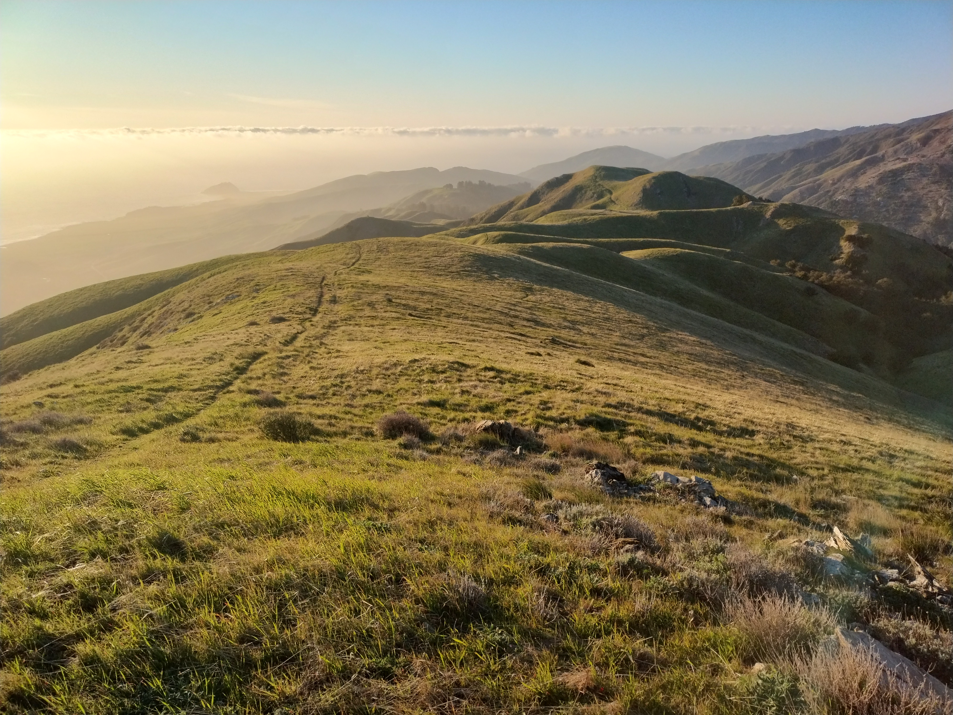
| Crown Point, Sawtooth Ridge, and Peeler Lake |
 |
| Crown Point and Peeler Lake |
Day 2: Friday, June 20th
By this point, we have made our way about a third of the way through the loop, and still don’t know whether we will reach a point that is impassable due to snow (there are no recent trail reports, and we haven’t encountered any clockwise hikers who can give us the intel). We are mentally prepared for the possibility that we may need to turn around in this scenario, but that would not be ideal. As we are making our way across the wide and flat Kerrick Meadow, we cross paths with two clockwise hikers who reassure us that yes, the route is passable, and all of the snow patches can be easily avoided. Woohoo!
Past the meadow, we turn east and climb forested switchbacks up toward Rock Island Pass (10,200’). This is our highest point of the trip, just above treeline, where the wind is intense but the sun is warm. We had planned on camping at Snow Lake beyond the pass, but it turns out that Snow Lake is essentially on the pass and seems very windy, so we decide to press on to Crown Lake instead. Past Snow Lake, the trail switchbacks steeply down a rocky gulch with great views of the peaks beyond and the valley below.
At Crown Lake, the wind is still very intense, but we find a relatively sheltered creekside camping spot and decide to stay. On our first day, we had encountered mosquitos in shady areas near water, but today's intense wind keeps them at bay. We spend most of the afternoon leaned against rocks at the campsite, staying just warm enough in the sun. In addition to the wind, the air temperature is much lower than the previous day. Towards the end of the day, we are greeted once again by our Audi friends as they make their way to a camping spot a little ways past ours. The woman who I had honked at says, “good to see you guys again!” but we have definitely gotten the vibe that they would rather not be seeing us at every turn.
We experience the sunset twice – first from our campsite, and then again, when we climb up on some prominent rocks and watch the sun finally dip beyond the far ridge.
 |
| Rock Island Pass |
 |
| Rock Island Pass and Snow Lake |
 |
| Descending toward Crown Lake from Snow Lake |
 |
| Slide Mountain |
 |
| Descending towards Crown Lake |
 |
| Slide Mountain |
 |
| Crown Lake |
Day 3: Saturday, June 21st
In the morning the surface of little ponds near our campsite are frozen over. After bidding good morning to our Audi friends, we continue on down the trail and descend past Robinson Lakes, beautiful and calm in the morning stillness. We pass the loop junction, return to the “stick” part of the lollipop, ford Robinson Creek, and then eat lunch on a rock overlooking Barney Lake. Back at Annette’s Mono Village, I feel a surge of gratitude as I buy three bubbly waters from the general store.
As I am walking into the bathroom, out comes Mr. Audi!
“You made it back!”
I respond, “see you at the hot springs?”
“Probably!”
Our final plan of the trip is to head to Buckeye Hot Springs, a natural spring that is just 15 or so minutes from the trailhead. It turns out to be the perfect end to our backpacking trip! We walk down a short trail that leads down to the main pools adjacent to Buckeye Creek, but before we reach the main pools, we stop at two pools that are fed by a spring on the hillside. Just as we show up, a group leaves the second of the two pools, and we have it to ourselves! Shortly thereafter we are joined by a friendly couple from Portland, who eventually migrate on to the main pools.
We discuss a plan to head down to Mammoth Lakes to see where Sierra lives, meet her boyfriend, and eat at the fancy French restaurant, where he is a sous chef! Although Mammoth is a bit out of the way from our original plan to head back over Sonora Pass, we decide to take Tioga Road through Yosemite instead so that we can enjoy a night in Mammoth. On our way out of the hot springs, we see an Audi parked in the lot…
In Mammoth, we enjoy a delicious dinner of French onion soup, potato leek soup, fried brussels sprouts, heirloom tomato salad with burrata, crusty baguette, chicken with creamy spinach sauce, elk medallions, vegetable wellington, ratatouille, and creme brulee. Incredible flavors! Sierra takes us on a tour of the many lakes around Mammoth, and we head up to Minaret Vista, where we see many of the peaks (Banner, Ritter, and the Minarets) where I was backpacking nearly a year earlier.
 |
| Robinson Lakes |
 |
| Robinson Lakes and Crown Point |
 |
| Barney Lake |
 |
| Pool at Buckeye Hot Springs |
.jpeg) |
| Cool tan girl and ghost in the spring fed pool |
Day 4: Sunday, June 22nd
After a frigid night sleeping in the truck (ice on the window of the cab), we wake up to our alarm at 4:30am and start driving. The only drawback of our Mammoth detour plan is that we need to get to the Yosemite entrance by 6am so that we can pass over the mountains on Tioga Road without a reservation. We make it just fine and then stop at Olmsted Point, where I make an Americano that we enjoy while looking east towards Clouds Rest, Half Dome, and Yosemite Valley.
 |
| Coffee at Olmsted Point, Half Dome in the background |
Epilogue:
The Eastern Sierra is an incredible place! Quickly becoming my favorite mountain area in California. Whereas the terrain on the western side climbs very slowly and steadily towards the crest of the mountains, on the eastern side the mountains rise steeply from high plains, allowing for relatively quick access to the alpine environments that I love. As I start to do more geothermal-related work, it is exciting to think about the possibility of doing some modeling of the deep hydrothermal systems underlying the Long Valley Caldera near Mammoth.
Raf and Sierra were great backpacking companions! I learned halfway through our hike that it was Sierra's first backpacking trip – this was a bit shocking because she was very prepared and seemed right at home. Through 24 miles of walking and 4000 feet of ascending and descending, positivity prevailed all around! The wind and cold on the second day kept us a bit chilly, but we appreciated the lack of mosquitos and intense heat. Dave and Amy were going to join this trip as well, but had to sit this one out after Dave hurt his knee hiking down from Mt. Shuksan in the North Cascades. We missed them!
In the next week, Raf and I are making the move away from Vida Verde and San Gregorio to a temporary home in the Santa Cruz Mountains near Ben Lomond! We are not sure how long we will be there – maybe a few months, maybe longer? There are two dogs there and a cat. Life goes on, there are more trails to walk.