
This past weekend I traveled north to the Lost Coast!
I have arranged to visit two properties: one on Salmon Creek Road outside of Miranda, CA, and the other on Conklin Creek Road near Petrolia, CA. Why am I checking out properties on the Lost Coast? Most of all, because it’s a fun and interesting way to explore the area. The cool and rainy climate is similar to the climate of Aysén, Chile, will likely stay cool and wet near the coast amidst climate changes, and would enable all sorts of homesteading, farming, and animal raising activities. Investors aren’t as interested in the area because it is so remote and Short-Term Vacation Rentals have been strictly limited by the county. Most of the properties are larger than 10 acres and have tons of water. As Raf and I are going to be in San Gregorio for the time being and may consider leaving the country down the road, I’m in absolutely no rush to do anything real estate related, but I still find it worthwhile to show up and ask questions, learn about easements, deeded access, spring vs. well water, grading codes, building permits etc. The agents know where I stand, so I’m not wasting anyone’s time.
On Saturday morning, I make my way to the coast on Philo-Greenwood road and then head north on the 1 through the fog. Past Fort Bragg, the landscape becomes much more rural and the coast more rugged, and then the 1 turns inland toward Legget – the southern edge of the “Lost Coast.” I drive winding roads through tall redwood forests, eventually meeting up with the 101 and continuing north to where Salmon Creek Road meets the 101.


I park and hop in Somer’s truck – she’ll drive us both up to see the spot. Along the way, we talk about the area and she reinforces many of the aspects that I find appealing. Turns out she knows my homesteader pen pals, a pair of back-to-the-landers who live outside of Garberville and have filled me in on all things Lost Coast over the past few years. The Salmon Creek spot has a beautiful, recently-constructed house and lots of water, but it is too hot. With increasing distance from the coast, maximum summer temperatures also increase: east of the 101, summer temperatures get into the 90s and 100s (with increasing fire danger), whereas west of the 101 (e.g. Salmon Creek), summer temperatures max out in the 80s and 90s. I realize during this visit that 80-90 degree weather is still too hot for me, and decide that I need to go even more coastal.
 |
| Salmon Creek property |
The distance from Miranda to Petrolia is not so great as the crow flies, but takes over two hours on winding roads that are only partially paved. Since Somer and I have wrapped up by about 2pm, I decide to make a “quick” detour to King Peak. This requires another slow and tedious drive up a winding dirt road that is washed out in my places: it takes me about an hour to drive 10 miles. But it is completely worth it! After parking at the trailhead, I run 2 miles up 2000 feet through thick forests into the manzanita shrublands of King Peak, with 360-degree views of the Lost Coast, King Range, Shelter Cove, and Mattole River Valley.


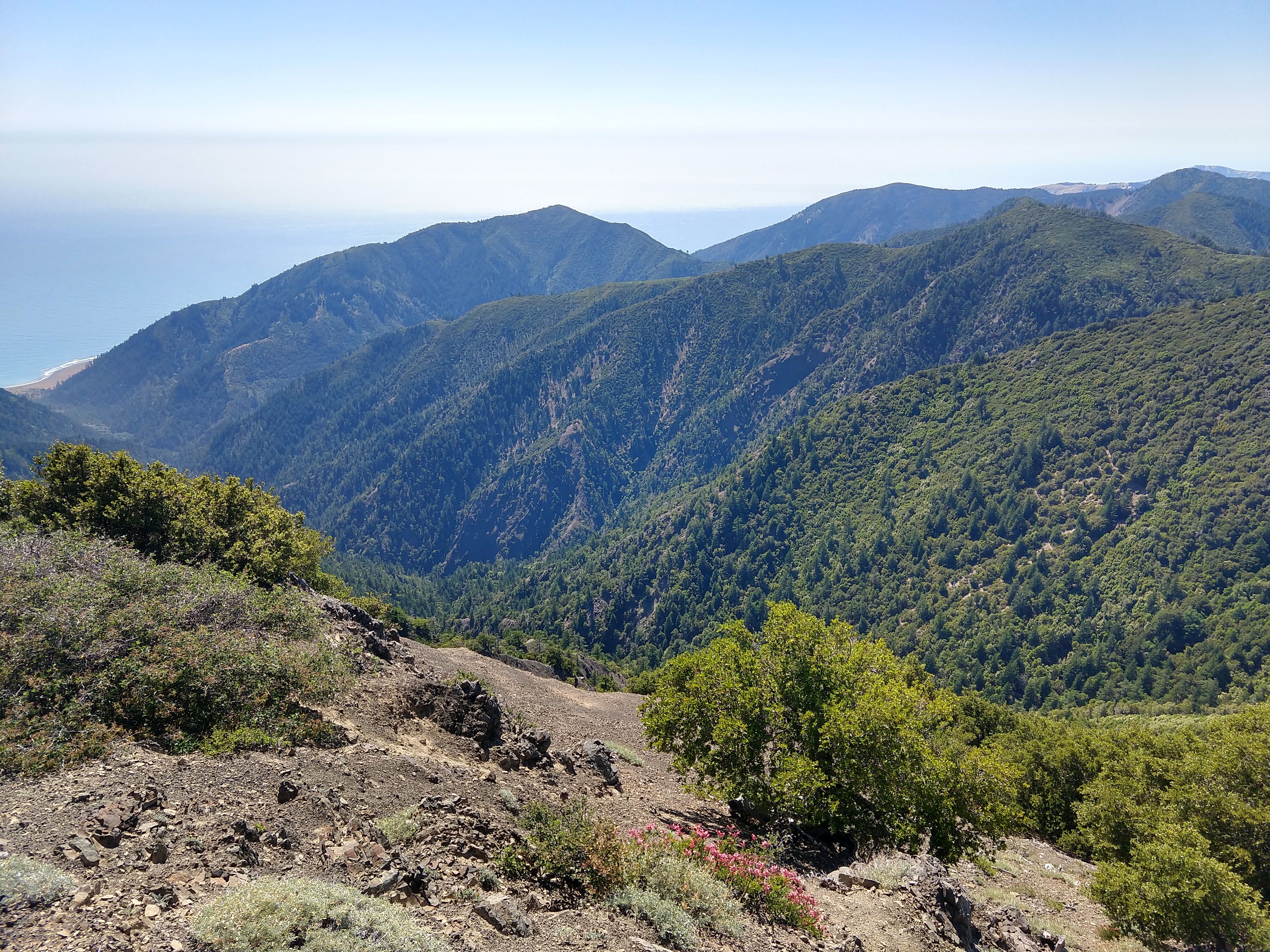
 |
| Note Shelter Cove in the upper left |


I’m pretty tired and hungry by the time I get to Petrolia, where there are few stores and restaurants. I decide to go check out the general store to see if I might find something to eat that is more interesting than the pear and jar of almond butter I have with me. Along the way, I notice a sign for “street tacos” at the Mattole Community Center! Turns out they are having a fundraiser – I eat four delicious tacos with beans and rice for $20. Miraculous!
 |
| Taco Miracle at Mattole Community Center |
I then make my way to the Mattole Trailhead, where the Mattole River feeds into the Pacific Ocean, walk along the beach for a while, and then sit and watch the sunset.


After a restful night in the back of the truck, I walk six miles round-trip on the Lost Coast Trail to and from Punta Gorda Lighthouse, where I see a couple colonies of elephant seals! I watch two rival males sparring – after a couple minutes of back and forth, the challenger on the left eventually backs off and the seals return to lounging.


 |
| Challenger is on the left |
 |
| The only acceptable way to approach an elephant seal is via a zoom lens |

 |
| Punta Gorda Lighthouse |

 |
| Lost Coast Trail |
I return to the Mattole Community Center, where they are serving coffee and breakfast! This is no church basement coffee either – flavorful and stimulating. I then make my way to the general store where I meet up with real estate agent Sandi, land owner Rodolfo, and another woman who had driven up from the Bay Area with her dog. We all pack into Rodolfo’s truck and head up Conklin Creek Road. The property we are visiting comprises three 160-acre parcels in a pristine valley with tons of water, wide meadow flats, and forests of madrone, douglas fir, maple, and redwood. Rodolfo shows me a trick with one of the trees (pepper tree maybe?): if you rub some leaves between your hands and then waft them, you get a wasabi-like sensation that clears your sinuses. Although it’s definitely warm and dry on the day we visit, ubiquitous ferns, moss, and green growth indicate that this area is generally cool and wet: in the Petrolia area, summer temps max out in the low 80s and winter temps bottom out in the high 40s – perfect! Afterward, I tell Sandi, the listing agent, to keep me in mind as she puts together her grand vision for selling these 480 acres. This property has sat on the market for years, and will likely drop significantly in price and/or require that the 160-acre parcels are sold separately, possibly even subdivided further. Big fan of Petrolia and surrounding areas!
I spend the rest of the day driving down winding roads: first east on Mattole Road to the Avenue of the Giants in Humboldt Redwoods State Park to the 101, where I head south to Ukiah and get a free burrito at Chipotle (I have a large supply of freebies after I politely notified Chipotle of an extremely salty burrito in San Rafael a couple weeks previously). I then take highway 253 southwest through oak woodlands from Ukiah to Boonville, hook northwest through Anderson Valley to Philo on highway 128, and then turn west onto Philo-Greenwood Road to the Dreaming Tower.
 |
| Mattole River |
 |
| Avenue of the Giants |
No comments:
Post a Comment