Monday, July 24, 2023

Volcano Country

A week ago I left the Dreaming Tower (near Elk, CA) and headed north to Bend, Oregon, where I’ve been staying with friends Dave and Amy for the last week. 

The drive is very scenic – oak woodlands and brown hills east of Ukiah along the shores of the vast Clear Lake, which apparently has the distinction of being the oldest lake in North America as well as California’s largest freshwater lake that is fully contained within the state (looking at you, Tahoe). The route then drops down into the Sacramento Valley before heading north on the 5 through Red Bluff, Redding, and Weed, past Mount Shasta to the Oregon border. The day I make the trip is the beginning of the second major El-Niño-and-climate-change-fueled heat wave of this summer, and the heat of the Sacramento Valley is oppressive: when I stop at In-n-Out in Redding for lunch, the temperature is 100 degrees. North of Klamath Falls, the highway climbs onto the high desert plateau of south-central Oregon and then winds through ponderosa pine forest to Bend. 

Since being here, I have played pickleball, floated the Deschutes River on tubes, run along Tumalo Creek, gone out for ramen, celebrated Dave’s birthday, and most recently, backpacked in the Three Sisters Wilderness. 

On Friday around 6:30pm, we hike four miles north along Fall Creek through forests of Douglas Fir, Western Hemlock, and Engelmann Spruce to Green Lakes, a series of beautiful lakes situated at the base of South Sister and Broken Top peaks. The shaggy hemlocks in particular catch my eye – they seem to glow green in the dim twilight, like a mash-up between the tamaracks of the boreal forest and the firs of the western forest. I'm so stoked to be back in the alpine zone I can barely sleep! 

The next morning, we pack our day packs and head up one of the drainages coming off South Sister. The hike is challenging: in contrast to many alpine areas that feature a band of grasses, mosses, and dwarf shrubs between ~10,000 and ~12,000 ft that stabilize the slope, the alpine zones of these stratovolcanoes are composed mostly of dusty, loose sands and gravels that tend to slide with each step. Still, the landscape is incredible: snow fields melting into icy streams incising channels through the loose rock. Dave is pet-sitting for one of his coworkers, so Mia the dog comes along too. We climb onto a saddle next to Lewis Glacier and a small blue cirque lake before ascending to the caldera (10,350 ft), where I do a quick lap and scope out some of the surrounding peaks: to the north are Middle and North Sister, Mt. Washington, Mt. Jefferson, and Mt. Hood, and to the south are Broken Top and Mt. Bachelor. We slowly descend South Sister to Green Lakes, submerge in the stream for a little relief from the intense afternoon heat, and then get into some freeze-dried meals: vegan orzo bolognese and pasta primavera (supplemented with tuna packet). 

The next morning, we hike up the drainage to the east onto a narrow ridgeline that leads up to the summit of Broken Top, a jagged and sinister volcano whose glacier-scoured walls reveal a long history of uplift and erosion, eruption and deposition. Aside from a couple spots where I "portaged" her up large boulders, Mia leads the charge. At the very top, I ascend one of the steep spires that crown the caldera and get my daily dose of fear. 

Reflecting on my time in central Oregon, I can’t help but notice that I am not as obsessed with this area as some other beautiful places I have visited in recent years. I guess I’m old and experienced enough to know what I like. While getting into the alpine zone this weekend was an incredible experience and a nice break from the heat of Bend, the arid climate of Oregon’s high desert (similar to the climate of Denver and Boulder) is just not all that appealing to me. In the same way that leaving the snowy mountains in Colorado for the hot and dry plains of the Front Range urban corridor always made me a little sad, Bend is just too far from the moisture, the coast, the coolness, the fog, the exciting weather for me. Not to mention it has filled with wildfire smoke a couple times since I have been here. In other words, I don’t get the appeal of living in a rain shadow, in a tinderbox. Western North America is generally very hot and dry, but full of all sorts of havens from the heat: steep canyons that block the sun for much of the day, wet coastlines buffered by the cool Pacific, high peaks that intercept snow and rain. These isolated patches of the “north woods” scattered throughout the west are the only places for me. I prefer gritty mountain towns with their general stores and post offices and fire stations over ritzy, suburban, mountain-adjacent towns with their breweries and strip malls. Of course, I am primarily here to visit Dave and Amy, and that has been wonderful. 

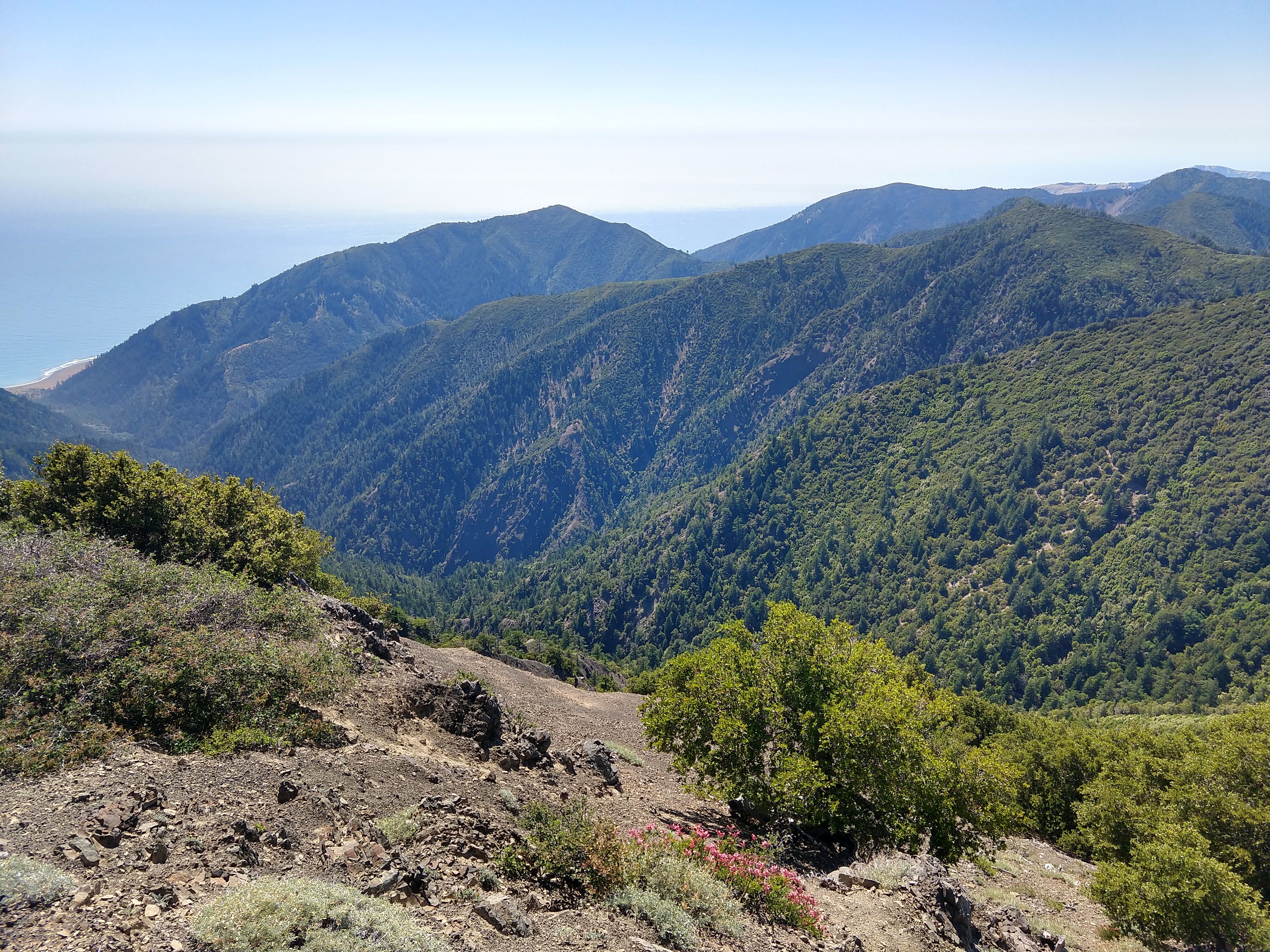
Most of the following photos are from our trip to the Three Sisters Wilderness this past weekend, but at the end I have included a few photos of coastal wildflowers from the tail end of my Mendocino Coast adventure to compare with the alpine wildflowers of this past weekend. 

Three Sisters Wilderness – Central Oregon:


Navarro Point - Northern California:


Tuesday, July 4, 2023

The Lost Coast

This past weekend I traveled north to the Lost Coast! 

I have arranged to visit two properties: one on Salmon Creek Road outside of Miranda, CA, and the other on Conklin Creek Road near Petrolia, CA. Why am I checking out properties on the Lost Coast? Most of all, because it’s a fun and interesting way to explore the area. The cool and rainy climate is similar to the climate of Aysén, Chile, will likely stay cool and wet near the coast amidst climate changes, and would enable all sorts of homesteading, farming, and animal raising activities. Investors aren’t as interested in the area because it is so remote and Short-Term Vacation Rentals have been strictly limited by the county. Most of the properties are larger than 10 acres and have tons of water. As Raf and I are going to be in San Gregorio for the time being and may consider leaving the country down the road, I’m in absolutely no rush to do anything real estate related, but I still find it worthwhile to show up and ask questions, learn about easements, deeded access, spring vs. well water, grading codes, building permits etc. The agents know where I stand, so I’m not wasting anyone’s time. 

On Saturday morning, I make my way to the coast on Philo-Greenwood road and then head north on the 1 through the fog. Past Fort Bragg, the landscape becomes much more rural and the coast more rugged, and then the 1 turns inland toward Legget – the southern edge of the “Lost Coast.” I drive winding roads through tall redwood forests, eventually meeting up with the 101 and continuing north to where Salmon Creek Road meets the 101. 


I park and hop in Somer’s truck – she’ll drive us both up to see the spot. Along the way, we talk about the area and she reinforces many of the aspects that I find appealing. Turns out she knows my homesteader pen pals, a pair of back-to-the-landers who live outside of Garberville and have filled me in on all things Lost Coast over the past few years. The Salmon Creek spot has a beautiful, recently-constructed house and lots of water, but it is too hot. With increasing distance from the coast, maximum summer temperatures also increase: east of the 101, summer temperatures get into the 90s and 100s (with increasing fire danger), whereas west of the 101 (e.g. Salmon Creek), summer temperatures max out in the 80s and 90s. I realize during this visit that 80-90 degree weather is still too hot for me, and decide that I need to go even more coastal. 

Salmon Creek property

The distance from Miranda to Petrolia is not so great as the crow flies, but takes over two hours on winding roads that are only partially paved. Since Somer and I have wrapped up by about 2pm, I decide to make a “quick” detour to King Peak. This requires another slow and tedious drive up a winding dirt road that is washed out in my places: it takes me about an hour to drive 10 miles. But it is completely worth it! After parking at the trailhead, I run 2 miles up 2000 feet through thick forests into the manzanita shrublands of King Peak, with 360-degree views of the Lost Coast, King Range, Shelter Cove, and Mattole River Valley. 


Note Shelter Cove in the upper left


I’m pretty tired and hungry by the time I get to Petrolia, where there are few stores and restaurants. I decide to go check out the general store to see if I might find something to eat that is more interesting than the pear and jar of almond butter I have with me. Along the way, I notice a sign for “street tacos” at the Mattole Community Center! Turns out they are having a fundraiser – I eat four delicious tacos with beans and rice for $20. Miraculous! 

Taco Miracle at Mattole Community Center

I then make my way to the Mattole Trailhead, where the Mattole River feeds into the Pacific Ocean, walk along the beach for a while, and then sit and watch the sunset. 


After a restful night in the back of the truck, I walk six miles round-trip on the Lost Coast Trail to and from Punta Gorda Lighthouse, where I see a couple colonies of elephant seals! I watch two rival males sparring – after a couple minutes of back and forth, the challenger on the left eventually backs off and the seals return to lounging. 


Challenger is on the left

The only acceptable way to approach an elephant seal is via a zoom lens


Punta Gorda Lighthouse


Lost Coast Trail

I return to the Mattole Community Center, where they are serving coffee and breakfast! This is no church basement coffee either – flavorful and stimulating. I then make my way to the general store where I meet up with real estate agent Sandi, land owner Rodolfo, and another woman who had driven up from the Bay Area with her dog. We all pack into Rodolfo’s truck and head up Conklin Creek Road. The property we are visiting comprises three 160-acre parcels in a pristine valley with tons of water, wide meadow flats, and forests of madrone, douglas fir, maple, and redwood. Rodolfo shows me a trick with one of the trees (pepper tree maybe?): if you rub some leaves between your hands and then waft them, you get a wasabi-like sensation that clears your sinuses. Although it’s definitely warm and dry on the day we visit, ubiquitous ferns, moss, and green growth indicate that this area is generally cool and wet: in the Petrolia area, summer temps max out in the low 80s and winter temps bottom out in the high 40s – perfect! Afterward, I tell Sandi, the listing agent, to keep me in mind as she puts together her grand vision for selling these 480 acres. This property has sat on the market for years, and will likely drop significantly in price and/or require that the 160-acre parcels are sold separately, possibly even subdivided further. Big fan of Petrolia and surrounding areas! 

I spend the rest of the day driving down winding roads: first east on Mattole Road to the Avenue of the Giants in Humboldt Redwoods State Park to the 101, where I head south to Ukiah and get a free burrito at Chipotle (I have a large supply of freebies after I politely notified Chipotle of an extremely salty burrito in San Rafael a couple weeks previously). I then take highway 253 southwest through oak woodlands from Ukiah to Boonville, hook northwest through Anderson Valley to Philo on highway 128, and then turn west onto Philo-Greenwood Road to the Dreaming Tower. 


Mattole River

Avenue of the Giants