
The idea for this trip began when I was interviewing for my current job with Neptune. I expressed that I should probably take some time off between gigs, as I hadn’t in a while, but they needed me right away and suggested that I take a longer trip in the fall, once the project had slowed down a bit. I can’t recall exactly where I heard of the John Muir Trail (JMT), but I knew that I wanted to take a long break from work, cars, screens, caffeine, and “content”. I had never set foot in the Sierra Nevada, a vast and tall range whose southern tip extends nearly into my backyard in Southern California. Although I was lucky to live in some beautiful places throughout my 20’s, I consistently prioritized my career and developed a bit of FOMO surrounding extended forms of human-powered travel such as bike touring and thru-hiking. Having defended my PhD thesis and graduated from my program three months into the pandemic, I never really had a chance to celebrate and take a breather. Thus, the time was right.
I was initially dismayed by the difficulty of getting permits for the southbound JMT starting in Yosemite as well as the northbound JMT starting at Mt. Whitney, but then I started reading about an alternate northbound route starting at Horseshoe Meadow. For those willing to walk an extra ~20 miles, the permit starting at Cottonwood Lakes and going over New Army Pass was much easier to obtain. About a month before the trip, I snagged one of these ($11) and began planning. I prepared enough to be responsible, but not so much that I knew exactly what to expect. I sent a 14-lb. “resupply” package to Muir Trail Ranch, halfway along the route. I packed my usual external frame pack, and with seven days of food, the thing was starting to get pretty heavy. It wasn’t that I had packed luxuries; it was just that my usual setup plus a week of food is not something I’ve carried in the past. I haven’t had to optimize every item in my pack for weight, since I had never gone on such a long trip. Still, I have a long and proud history of walking and skiing with heavy packs, so I didn’t think much of it. I packed a bear canister (thanks parents!), mobile solar panel (thanks Aunt Elizabeth!), and blue dish scrubber (thanks Aunt Peg!). I was ready.
Day 0 (Saturday, September 3): San Diego to Horseshoe Meadow
After spending the morning with Raf, I say goodbye and then start heading north. Within ten minutes, I realize I had forgotten my blueberry almond flour cakes in the fridge and run back to get them. I then drive about five hours north through San Diego, Riverside, and San Bernardino counties, cross the high desert, and turn east at Lone Pine to head up into the mountains. On the eastern side, the jagged massif of the Sierra Nevada juts steeply up over 6,000 feet from the desert in a dazzling transition from dry sagebrush to pine forest. The drive along narrow switchbacks to the trailhead is terrifying: knowing that one slip of the wheel would send me rolling thousands of feet down to my death is enough to keep me on edge. After about thirty nervous minutes, I arrive at the Horseshoe Meadow campground (~10,000 feet), relieved at the coolness after hours in Southern California’s most intense heat wave of the year. The landscape is extremely rocky: the ground surface is entirely gravel with dead trunks strewn about and intermittent lodgepoles providing some shade. After strolling around, I climb in the back of my truck and go to sleep.
Day 1 (Sunday, September 4): Horseshoe Meadow to Crabtree Meadow (22.5 miles)
I wake up at the break of dawn and start walking. I know that the first day will be absolutely brutal, given my lack of pack training and the fact that I came from sea level less than 24 hours before, and I am not disappointed. With seven days of food and all my gear, my pack is somewhere around 60 lbs. My Rooseveltian motto of the day is “walk swiftly and carry a heavy pack.” By the time I get to the top of New Army Pass, I imagine that I have walked something like 15 miles, but two guys who I meet on the pass inform me that I had only walked 8. I learn that they are former scout leaders doing the trail over a span of thirty days, with “lots of naps.” I descend the west side of the pass and walk for a long time before getting to the Rock Creek campsite. There, I see a sign that indicates only four more miles to Crabtree Meadow, which is where I will join up with the JMT. As this stretch of trail is not part of the JMT, I only have a handful of map screenshots to go by, so I don’t notice how many elevation contours these four miles cross, as well as the minor Guyot Pass (~10,000 ft) that I must go over. I am pretty beat, but I decide to go for it so that I can hit the JMT the next morning. Three hours later, dusk is approaching and I am still not at Crabtree Meadow. I am so tired I have to take a break every quarter mile. Finally, after hundreds of feet of up and down, I stagger into the campsite at Crabtree Meadow, set up my tent, eat some salmon packets and a few spoonfuls of almond butter, and go to sleep.


Day 2 (Monday, September 5): Crabtree Meadow to Forester Pass (13.6 miles)
In the morning, I am very motivated to lighten my pack so I cook up a bunch of lentils with coconut cream. I am feeling pretty good about this choice until, after a couple hours of ascending, my stomach decides to rid itself of this extra weight. Sad to waste the food - no more lentils for breakfast. I finally hit my stride in the afternoon, when the combination of a beautiful trail leading up into the alpine tundra, friendly people on the trail, and a general sense of ease and fitness throughout my body puts me in a great mood. After some 24 hours in the subalpine meadows and forests, I am ready for the alpine zone! I make it all the way up to Forester Pass, which I will cross in the morning when I’m feeling fresh and the air is cool. I realize early on that the afternoons will be a challenge on this trip: the heat and dryness are nothing short of oppressive. I am struck by just how rocky these mountains are: it is obvious that these are very young and fresh mountains, barely weathered by the elements and only recently colonized by tundra vegetation. At 40 million years, the Sierras are slightly younger than the Rockies (80-55 million years) and significantly younger than the Appalachians (480 million years). I set up camp near a windy tarn, where I wash my face, eat some more fish packets and almond butter, and go to sleep.


Day 3 (Tuesday, September 6): Forester Pass to Rae Lakes (12.1 miles)
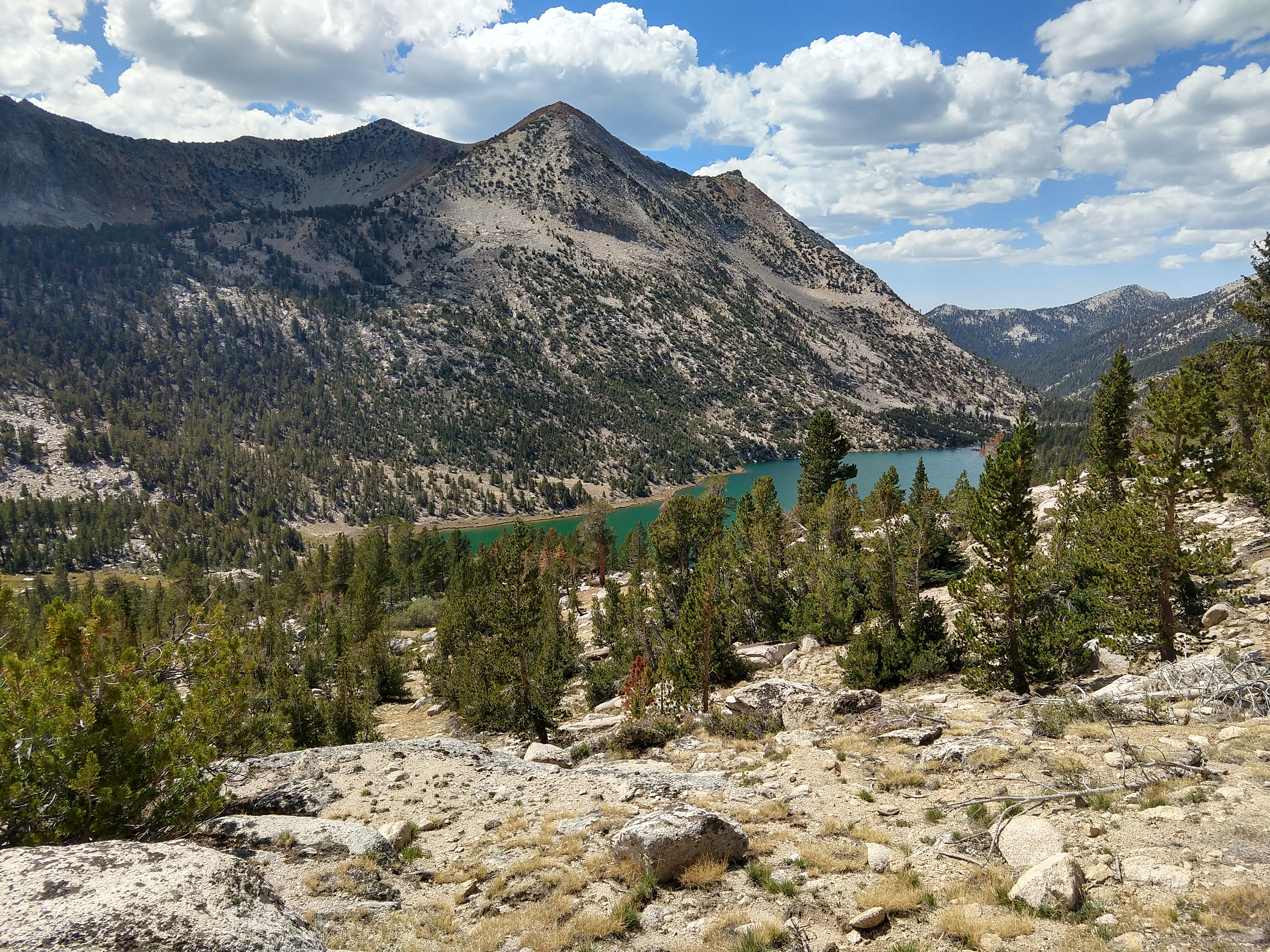
Today is a two-pass day. I hop Forester in the morning and cross from Sequoia National Park into Kings Canyon National Park. By the time I start heading down the north side of Glen Pass, I’m getting pretty tired of descending. Walking downhill, I feel the full weight of my pack along the front of my legs: the top of my ankles, front of my shins, front of my quads. I had aimed for Dollar Lake, a few miles north of Glen Pass, but after two passes, I am pretty beat so I decide to call it at Rae Lakes. Turns out this is an extraordinarily beautiful spot, reminiscent of Snowmass Lake on the Aspen Four-Pass Loop: a massive granite face rises from the deep blue alpine lake. I find an incredible campsite perched on a rock outcrop overlooking the lake and the mountains behind. I finally have time and energy to make a good dinner (almond butter rice noodles) and take care of myself: jump in the lake, brush my teeth, stretch, and sit around for a while. It is clear that this walk will fundamentally be a self-care challenge: can I maintain my body well enough to finish the trail? There is a soreness in my calves that won’t go away, so I supplement with a brown rice protein beverage. On the way up from getting water at the lake, I drop a Nalgene and it breaks! It must not have been a real Nalgene, as I’ve never heard of such a thing. I am missing Raf a lot; it is hard knowing that I won’t see her for another week and a half, and have no idea when I will be able to even talk to her.


Day 4 (Wednesday, September 7): Rae Lakes to Marjorie Lake (16.3 miles)
Only one pass today – Pinchot. It’s a long hot slog through the subalpine forest up to the pass, but by the time I am above treeline, some cloud cover shields me from the harshness of the afternoon sun. It has become clear that this trail follows a distinct pattern: after going over a pass (11,000-13,000 feet), I descend through talus slopes and scree fields, then the windy tarns, then the alpine tundra, and then the subalpine meadows and forests. I follow the stream down until it converges with another stream (7,000-9,000 feet), cross into the other drainage, and then ascend through the subalpine meadows and forests, into the alpine tundra, past the windy tarns… and the game repeats. Uphill is challenging and fun, flat is easy, and downhill stinks. Rain comes on as I am just reaching my campsite at Marjorie Lake – it is welcome after many hot days. My self-care routine continues to improve: tonight I rub coconut oil on my sore feet. I have found that the key to minimizing leg soreness is eating/drinking tons of protein and getting plenty of rest (seems obvious, but after a day of hydrating excessively, it can be difficult to minimize wake-ups in the middle of the night). I eat a bunch of instant refried beans, one of my favorite dinners so far. I’m feeling pretty good about my progress as I go to sleep listening to the thunder above.


Day 5 (Thursday, September 8): Marjorie Lake to Kings River (19.6 miles)
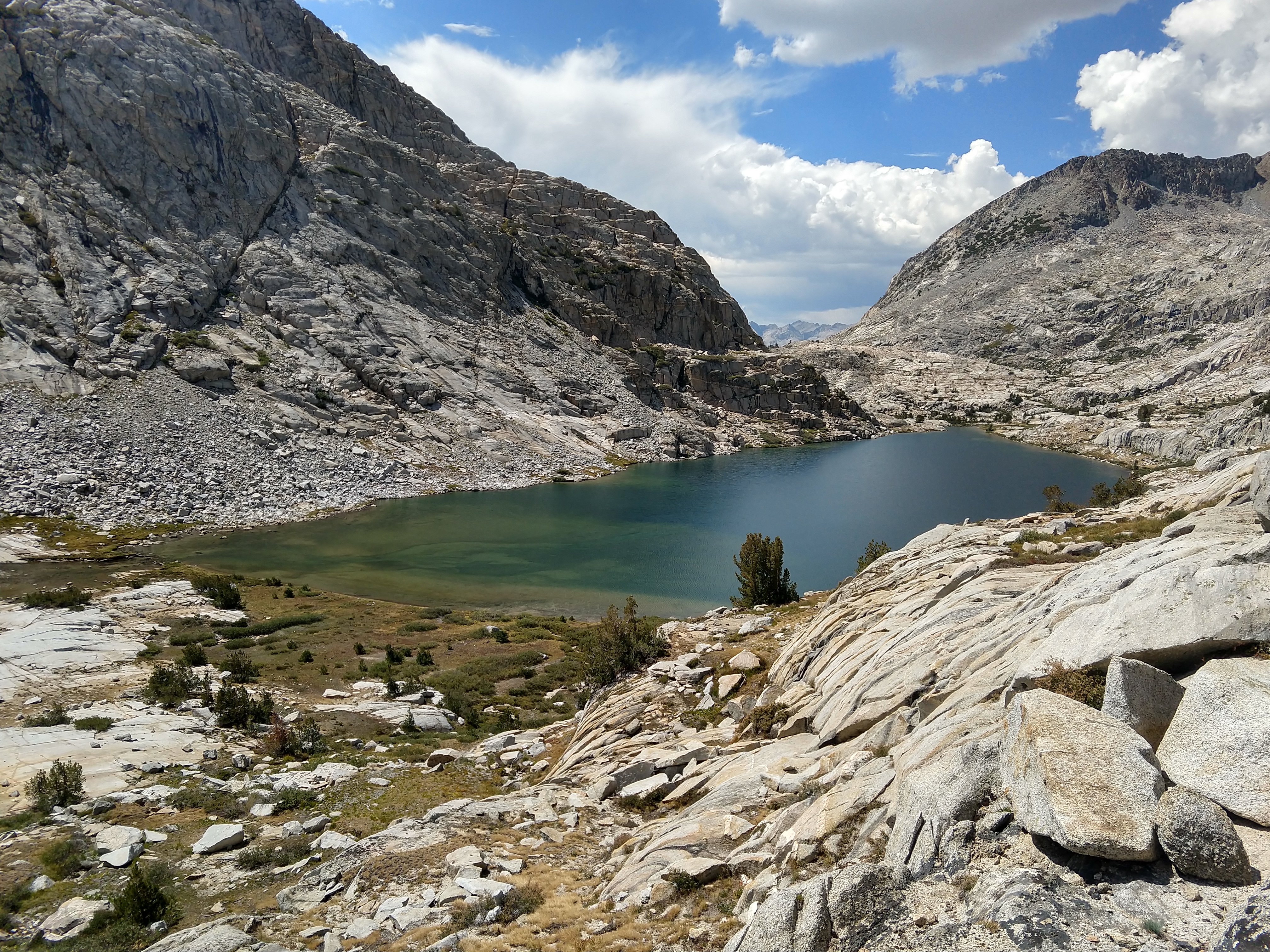
It’s a great walk up to Mather Pass: the trail between Pinchot and Mather is short (~8 miles) and only descends down to 10,000 feet, saving me a ton of downhill and uphill. The far side of Mather Pass is epic: at the base of scoured granite walls lies the shimmering sapphire Palisade Lakes. I descend the steep gorge north from Palisade Lakes to the confluence of Palisade Creek and the Middle Fork of the Kings River, where I set up camp.


Day 6 (Friday, September 9): Kings River to Evolution Lake (16.8 miles)
Muir Pass is a very long, but incredibly cool ascent through another glacial gorge. I keep thinking I am near the top of the pass, but then I come over a rise and see yet another alpine lake and yet another set of switchbacks leading ever higher. At 11,617 feet, the massive blue Helen Lake blows my mind. The phrase "mountains are the water towers of the West" pops into my mind. On the top of Muir Pass, near the little stone hut that looks like somewhere Jack Kerouac would have spent time, I shoot the shit with two other solo JMT hikers (both southbound). Exchanging tips and tricks for recovering after a long day, it feels really good to connect over our shared, but independent experiences and relate through our mutual love of the highs and lows of mountain adventures. People in groups don’t seem to know what to make of solo hikers and vice versa, so it’s a huge relief to come into a conversation from a place of instant understanding. Annoyingly, it is Friday night so Evolution Lake is a little busy with weekenders when I roll into camp. Lots of raw wilderness stoke today – Muir Pass is pretty mind-blowing.


Day 7 (Saturday, September 10): Evolution Lake to Sallie Keyes Lakes (21.7 miles)
I realize that I am very close (~10 miles) to my resupply at Muir Trail Ranch (MTR). I’m not so much excited about additional food as I am about the possibility of communicating with Raf – I have been checking for cell service on every pass without success. I bust my ass down to MTR through the Evolution Creek basin in misty rain, when without warning I get caught in a massive thunderstorm with high winds and heavy rain. By the time I get to MTR, I’m pretty soaked and have my fingers crossed that they have an indoor space to rent for the night (a few days earlier some hikers descending Muir Pass had told me they had an excellent night staying at an MTR cabin). I am trying not to hold my breath, but I can’t help but dream of the opportunity to sort myself out indoors. When I finally arrive at MTR, it turns out their cabins are closed for the season, they don’t have Wi-fi, and I don’t have cell service – I get to send a single email to Raf. I pick up my resupply bucket, repack my pack under a canopy, and snag a couple free freeze-dried meals from the hiker box (Beef Pasta Marinara and Chicken Wild Rice Pilaf). The day remains cool and drizzly with occasional heavier rain as I ascend again toward Selden Pass. There are few photos for today (and the subsequent days) for several reasons: (1) with consistent cloud cover, I can’t charge my battery pack so I decide to save phone battery for essentials; (2) the drizzly rain has me nervous to keep my phone handy; (3) after the trail stretches in Kings Canyon, the lower-elevation areas north of Evolution Lake are more enjoyable from a sort of walk-through-a-misty-forest perspective than from a take-photos-of-jaw-dropping-views perspective.

Day 8 (Sunday, September 11): Sallie Keyes Lakes to Mono Creek (14.9 miles)
The morning is clear and I hop over Selden Pass (if you can even call it a pass at 10,898 feet). I sneak in some solar panel charge time before the cloud cover returns in mid-morning. After descending below treeline once again, I am struck by how similar the landscape is to Rocky Mountain National Park and the areas surrounding Estes Park: thick lodgepole pine and douglas fir forests with occasional granite outcrops. I am also amazed how much the ground cover has changed: in contrast to the extremely dry and gravely slopes of Sequoia National Park, the forests of the Sierra National Forest appear almost lush with vegetation and undergrowth. I miss Raf a lot, especially when I pass by beautiful alpine lakes and rushing streams, set up camp at the end of the day, and cook dinner. Tonight, I enjoy both of the freeze-dried meals that I snagged at MTR: after days of the same vegan foods and fish packets, Beef Pasta Marinara and Chicken Wild Rice Pilaf are super exciting and delicious!
Day 9 (Monday, September 12): Mono Creek to Deer Creek (19.9 miles)
In the morning, I ascend back into the alpine tundra on Silver Pass, woohoo! After descending Fish Creek and climbing through a sort of gap in the mountains called Tully Hole, the rain starts around 2pm. It is nothing like the heavy rain and whipping winds of the past Saturday, but it is steady. Since I am already geared up, I decide to keep moving and push as far as I can for the day. When I make it to Deer Creek, I’m pretty cold and soaked and the rain is showing no signs of letting up. Shivering, I put up the tent and scramble to throw together some instant refried beans in the rain. The hot beans with coconut oil, onion flakes, and berbere are incredibly delicious and give me just the boost I need to stay positive. This is undoubtedly one of the most challenging points of the trip: wet and cold is a game you can only play for about 24 hours before things start to go downhill, so I am definitely concerned about how long this rain might continue.


Day 10 (Tuesday, September 13): Deer Creek to Garnet Lake (19.6 miles)
I bust my ass to Reds Meadow (a “resort” and resupply spot) in the morning, with the hopes of getting cell service, checking the forecast, and figuring out my end game. When I arrive, I do not have cell service, but I notice that there are a bunch of Verizon folks getting service. I strike up a conversation with Michael from Philly, who lets me use his hotspot to figure my life out. I offer to pay him for it, but he refuses - thanks Michael from Philly! I find out that the rain, which originated from a storm in Baja California, is forecast to pass within the next day. I also text Raf, text Dave, email my folks, and make a whole bunch of changes to the logistics on the tail end of my adventure. The key factor is that one of the buses that will take me back to my truck only runs on weekdays: initially I had planned on taking the Monday bus, but by this point, I realize I need a full weekend to unpack and sort things out before returning to work, so I decide to exit the wilderness on Thursday at Tuolumne Meadows and take the Friday bus. This also involves skipping the descent into Yosemite Valley, which I decide to avoid for several reasons: (1) I would rather not descend 6,000 feet if I don’t have to; (2) Yosemite Valley is full of smoke from a nearby fire; (3) Yosemite Valley is the epicenter of the car-centric National Park experience. After Reds Meadow, I ascend once again! After many miles and a mini unnamed pass, I am awestruck by Garnet Lake. Lying at the base of an incredibly beautiful mountain face holding an alpine glacier, Garnet Lake is dotted with many small islands. I find an excellent campsite perched on the hillside, cook some more instant refried beans, and watch the clouds swirl around Banner Peak before going to sleep.


Day 11 (Wednesday, September 14): Garnet Lake to Lyell Fork (10.8 miles)
This morning is one of the most special times of the entire trip. Waking up to frost on the ground, I recognize that at some point throughout the morning, the sun will come over the rim of the surrounding ridges and illuminate the east-facing Banner Peak and its alpine glacier. I assume this will take a while as the surrounding ridges are pretty high, but by 7am, Banner Peak is already glowing orange. I run around to different parts of the lake, giddily grabbing shots of this extraordinarily beautiful mountain face, feeling like a kid in a candy store. The morning is clear and sunny. I’ve seen some impressive natural beauty in my short time, but holy smokes! I’ve never seen anything like Banner Peak and Garnet Lake with its many islands. I am filled with a primal joy that I haven’t experienced in a long time, that sense of being in exactly the right place and the right time, humbled and awed by this giant block of granite that is so astonishingly God-like. Eventually I ascend the ridge on the north side of Garnet Lake, which leads down into yet another jaw-dropping lake at the base of Banner Peak, Thousand Island Lake. I continue in amazement on my way up to Island Pass, descend to Rush Creek, and then back up and over Donahue Pass, where I finally get service, woohoo! I descend into the Lyell Fork basin and set up camp a little early so I can dry my gear, hang out by the creek, and make a good dinner. By this point, all I can think about is food: I dream of Thanksgiving style dinners, the chicken and potatoes from Dave’s wedding, Bon Appétit magazine’s lemon pasta. I come up with an idea to make salmon salad with avocado oil based mayo and Trader Joe’s canned salmon and spread it on Everything bagels.


Day 12 (Thursday, September 15): Lyell Fork to Tuolumne Meadows Visitor Center (13.2 miles)
Another freezing night! Ice on my tent poles in the morning. I slowly walk along frosty meadows down Lyell Canyon to the Tuolumne Meadows area, arriving about 1pm. This is about the rudest awakening imaginable, as they are repaving the road when I arrive. Hordes of diesel trucks and jackhammers sending clouds of dust and toxic fumes into the air. Being within Yosemite National Park, Tuolumne Meadows is also full of people hopping out of cars, taking selfies next to rocks and streams, and then hopping back into the car to head to the next destination. I could just about hear Edward Abbey chuckling alongside me. About a mile from the visitor center, I encounter an obnoxiously chipper man who looks at me and loudly states, “Wow, he looks like he’s ready for something!” I walk to the general store in search of sparkle water. I don’t find any, but I talk to a cool store attendant who suggests that I instead walk to Soda Springs, a naturally carbonated spring a mile away. My bus isn’t until 6:45pm, so I spend a while at Soda Springs, drinking the (mildly) carbonated water – couldn’t imagine a better way to wrap up my trip! I spend the rest of the afternoon hanging out by the Tuolumne River. At the peak of the afternoon heat, I jump in. I am amazed at how patiently I am able to wait – usually waiting hours for a bus would drive me nuts, but I seem to be filled with a limitless reservoir of chill, relaxation energy. The Yosemite Area Regional Transit System (YARTS) bus ride from Tuolumne Meadows to Mammoth over Tioga Pass is beautiful and terrifying – another one of those roads carved into the side of a steep mountainside that looks like it could crumble at any second. I check into my hostel, take a shower, and go to sleep.


Day 13 (Friday, September 15): Mammoth to Horseshoe Meadow
In the morning, I catch the Purple Line shuttle to Vons, get a coffee at Starbucks (my first cup in about three weeks!), and then hop on the Eastern Sierra Transit Authority (ESTA) bus to Lone Pine. On the bus, I talk to a long-time Mammoth resident who is on his way to meet up with his Brazilian fiancé, get married, and then move to Brazil. We talk skiing, mountain towns, and the John Muir Trail. Despite the smoke that has filled the valley, the bus ride is very scenic: the Eastern Sierra feels like another world, almost like Latin America, with dry sagebrush ranches along the small streams trickling off the steep eastern side of the Sierra Nevada. Jazzed by my cup of coffee, I feel that morning travel stoke, that excitement of experiencing a new place via public transit, that sense that the world is a limitless place of natural beauty and kind people. I get dropped off at McDonalds in Lone Pine, where I wait for Lone Pine Kurt, who will give me a lift back up to Horseshoe Meadow. Thankfully, he has found someone else who needs a ride, so we both get half off! My truck, undisturbed by bears (after seeing a photo in the Tuolumne Meadows Visitor Center, I was a little nervous the soap and toothpaste in there might attract a bear), starts right up and I am off. Music sounds so good as I wind down the narrow switchbacks. Somewhere in San Bernardino county, there is a Five Guys next to a Chipotle. I first eat a lettuce-wrapped burger with tomatoes, onions, peppers, and mushrooms at Five Guys and then go get my usual burrito bowl at Chipotle.
I'm going to take a page from Aunt Carolyn's book here...
Favorite Trail Stretches?
Kings Canyon was consistently impressive. With the highest elevations of the trip, I got to spend lots of time in the alpine tundra, my favorite mountain environment. The glacial lakes at the base of Banner Peak were also a highlight.
Least Favorite Trail Stretches?
Sequoia National Park felt barren and dry – gravel interspersed with dead trunks and sparse trees.
Favorite Campsite?
The spot at Rae Lakes, perched on a rock with a view of the lake.
Food Highlights?
I loved the instant refried black beans I had brought, especially with coconut oil, onion flakes, and berbere. The freeze-dried Beef Pasta Marinara and Chicken Wild Rice Pilaf I snagged at MTR were also pretty exciting.
What did you think about on the trail?
Raf, dinner (especially when it was instant refried black beans), the day’s itinerary, Raf, food, nothing.
Would you do it again?
I would consider doing certain stretches with a significantly lighter pack and reservations at one of the “resorts” along the trail. After backpacking, a night in a cabin would feel incredible. Overall, I don’t really feel the need to go on long thru-hikes in the future. I get plenty of enjoyment from a trail run or a single overnight. As I age, it’s becoming less appealing to sleep on the ground many nights in a row. The lack of fresh and protein-rich food also took a toll on my body: looking in the mirror after the trip, I was a bit shocked at how gaunt I had become.
How did you purify water?
I mainly drank stream water through a LifeStraw. The trail has tons of water and hydrating at streams became a sacred ritual (I also carried one liter with me). I also did what I call “overnight iodine” – if you are willing to wait a longer time (overnight instead of a half hour) less iodine is required to disinfect water (one tablet instead of two). This way, I reduced the amount of iodine I was consuming, but still enjoyed a liter of water I could gulp in the morning without having to use the LifeStraw.
Did you have fun?
Not applicable. It was more like going to church or the gym. There were many hours of joy, but also some hours of discomfort and drudgery.
Did the miles fly by?
Sometimes they did, but I generally found that the miles took about twice as long as I expected. I talked to a lot of folks using GPS who said that the mileages in the National Geographic Map are all erroneously short by significant amounts, ~1 mile for each segment. I’m guessing this trail was mapped using a really low-resolution method that doesn’t accurately account for twists and turns, switchbacks etc.
What would you change about your pack?
I would definitely replace the Keen sandals I brought as "evening shoes" with lightweight Crocs. I would skip the cotton T-shirt, tank, and pillow case in favor of polyester material that doesn't retain water (and weight). I would replace my rain jacket and windbreaker with a single waterproof, lightweight "shell". I would replace my heavy pocketknife with a lightweight blade. I would change my sun strategy to rely on covering skin with lightweight clothes, rather than with lots of heavy sunscreen. I would probably bring half as many socks - I brought six or seven pairs of Darn Tough socks and three pairs of wool socks. It was so nice to have fresh ones, but also a bit of a luxury. I would also try out an internal frame pack - my external frame was generally uncomfortable and squeeked all day during the last two days of the trip.
What was the first thing you cooked when you got home?
I basically did a mash-up of Bon Appétit magazine's lemon pasta and the chicken and potato dinner from Dave's wedding. I cooked a bunch of Sonoma County's finest pastured, free-range chicken breasts in the crockpot with garlic, butter, and rosemary. I roasted some red potatoes in coconut oil. I poured the chicken juice + garlic + butter mixture into a sauce pan, added a few cups of heavy cream, the zest from three lemons, and the juice from one lemon and brought it to a boil. I slowly stirred in a few cups of grated parmesan and then poured this sauce over the chicken and potatoes. It was absolutely incredible.
If you enjoyed this post, please go like the link on Facebook so that other people see it.
No comments:
Post a Comment