I love Big Sur and the Santa Lucia mountains. Compared to the San Francisco Peninsula, the rugged coastline of Monterey County feels distinctly southern, more like the Santa Ynez mountains to the south than the Santa Cruz mountains to the north. Although parched brown redwoods cling to the steep gullies, shrubs dominate these mountain landscapes, with hilltop oaks on meadow ridges offering a break in the thick chaparral. Apparently the Esselen people have lived in the Santa Lucia mountains for over 8000 years; due to the plentiful seafood and acorns along the Big Sur coast, they remained hunter gatherers until Spanish colonization.
I have visited this coast on two previous occasions: first in November, 2021, traveling north on Highway 1 with Raffelina and second in March, 2024, traveling south from Monterey and then driving into the mountains on Palo Colorado Road. Spring is a special time in the Santa Lucias, when the creeks are running, the hillsides are lush from winter rains, and the shrubs glow green before returning to their usual brown and gray. Even in spring, however, the agaves, manzanitas, ceanothus, bleached gravel soils, and pale sun that I came to know in southern California give the slopes a dry feel.
In some ways, these mountains are ideal for exploring – low shrubs offer frequent views, while oak woodlands along the streams and gullies offer shade and shelter from the wind. However, the Ventana Wilderness has been largely neglected by the Bureau of Land Management, the United States Forest Service, and the non-profit Ventana Wilderness Alliance that has been charged with trail maintenance, and crews of vigilante locals have taken the initiative to maintain the trails themselves. Still, these volunteer crews can’t keep up with the pace of the shrubs, and many trails are completely impassable due to thick deadfall or bridges blown out by high spring flows. Hiking crouched over with forearms extended vertically on either side of the face is a common occurrence. I’ve written previously about how the Ventana Wilderness feels abandoned, with lots of rotting picnic tables, rusting fire grates, and illegible trail markers. Along with the steep and challenging terrain, these factors discourage people from traveling deep into the wilderness and the trails are pretty empty.
On the other hand, the Highway 1 corridor is extremely popular with tourists, influencers, van-life enthusiasts, and residents of the Monterey Bay area, who all seem to converge on the same few parks on the northern part of the coast (Point Lobos and Garapata), especially with the indefinite closure of Highway 1 south of Julia Pfeiffer Burns State Park, which prevents visitors from accessing this coastline from the south. So, as with many beautiful places, there is an unfortunate need to weave through the crowds and traffic, but with a little effort it’s possible to escape to quiet and beautiful places.
I haven’t written much recently, mainly because I’m doing all the same things and going to all the same places, just in different seasons. I am motivated to enjoy the spring as thoroughly as possible – starting in March, the sun feels warm in between the rains and sets late enough that the golden hours of evening feel long and luxurious. In recent months, a multitude of factors have led me to shift into a more primal mode of existence, with the simple goal of enjoying the day, spending lots of time with Raf, experiencing nature, cultivating joy through movement, eating good food, and drinking bubble water with lime juice. With my mountain bike out of commission, I started to run much more frequently on the trails / roads at the ranch across the road (every day vs. 2-3 days / week). I pride myself on my ability to enjoy the same place repeatedly, always finding new angles and perspectives and movements, but after a couple weeks of the same, I was ready to admit that I was a bit bored of the hills across the road.
So I’ve been wanting to explore new coastal hills – last weekend, Raf and I visited the Sonoma coast for the first time and walked the meadow trails of Jenner Headlands Preserve, and next month, we are planning on hiking and camping at Point Reyes. In my return to Big Sur, I am on the hunt for coastal trails that climb steeply up green hills to granite ridges. My goal is to maximize my time on the trails without a heavy pack and enjoy a good night’s sleep in the comfy bed in the back of my truck. I watch the weather for a couple weeks, waiting for a rain-free window, and then pull the trigger on the morning of Friday, March 7, conveniently the same day Raf is heading to San Diego.
Adventure #1: Post Summit and Mt. Manuel (13.3 miles; 5242 feet of elevation gain)
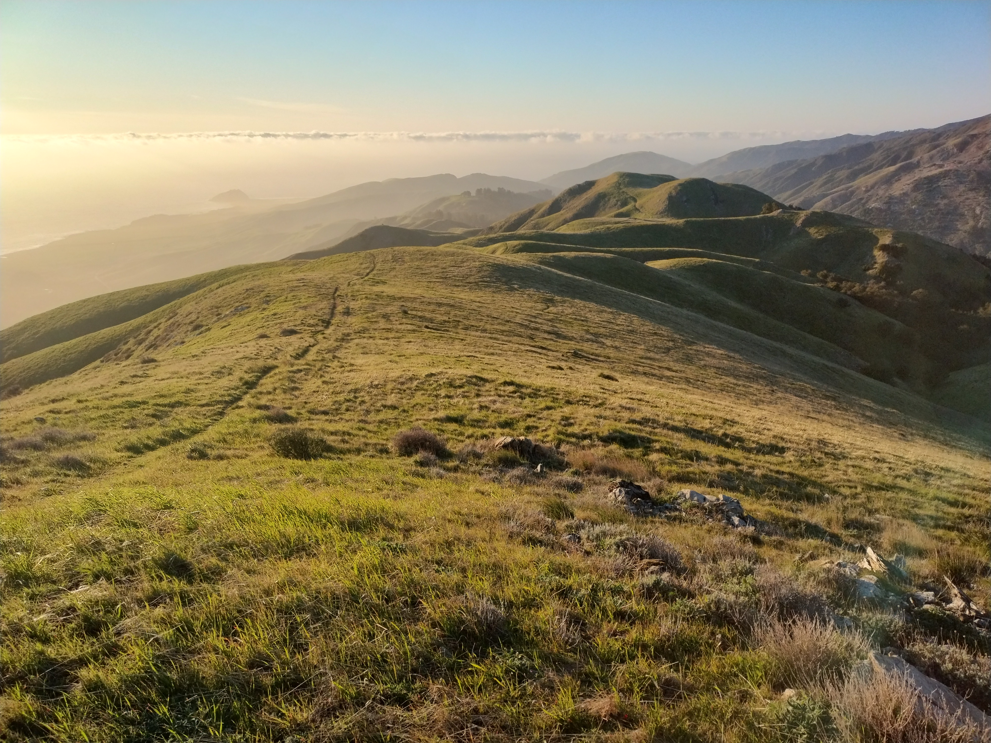
I throw some water, snacks, and clothes in the truck and then head south on the 1 towards Santa Cruz, along Monterey Bay past Carmel and the Monterey Peninsula, over the Bixby Canyon Bridge, and then out onto the cliffs of the Big Sur coastline. After a short while, I arrive at the trailhead on the highway near Andrew Molera State Park, fill up my new hydration pack, and then start running up the trail, around 1pm. The destination is “Post Summit”, a nice 3460-ft ridge overlooking the coastline, though the map indicates there may be a connecting route southward along the ridge to Mt. Manuel (3550 ft), a peak that I ran up four years ago from the south via Pfeiffer Big Sur State Park. The trail switchbacks steeply up dry shrub slopes (lots of poison oak) and then undulates along grassy meadows, with views of Pico Blanco, a prominent limestone peak that has been the subject of several disputes between developers and the California Coastal Commission. I wonder how the meadows stay meadows and don’t get colonized by shrubs – maybe they are seasonally grazed? Near a grassy outcrop with a fresh picnic table, the trail saddles over to a steep shrub slope in the final push to Post Summit.
At Post Summit, I see the ridgeline route to Mt. Manuel laid out before me to the south: it undulates along hilltop meadows and shrub ridgelines to a narrow catwalk leading to the broad summit(s) of Mt. Manuel. Post Summit and Mt. Manuel not especially prominent peaks, really just rocky high points along the coastal ridge. One of the most beautiful landscapes of the Santa Lucia mountains are the oak and madrone woodlands that crown many of the steep hillsides. For a Minnesotan accustomed to the oak savannahs along the Mississippi River valley, there is something exotic about gnarled oaks on the tops of ridges. After many ascents and descents, I finally arrive at the summit of Mt. Manuel where I had stood four years ago seeing the Santa Lucias for the first time. I look south towards the shrub slopes glowing in the late afternoon light, draped like curtains from the jagged crest to the misty ocean. I look northeast towards Skinner Ridge, Pat Spring, and Ventana Double Cone, where I had backpacked a year earlier and watched the sunset from a high hilltop campsite. I love returning to places I have already visited, especially from a new angle and during a different season. I am really enjoying my new hydration pack – it is nice to have the confidence to go long distances, without the weight of a full overnight pack.
By the time I get to Mt. Manuel, it is about 4:30 – I have been on the trail for over three hours. Although I ran much of the way to Post Summit, I had walked the ridgeline due to general tiredness and wanting to enjoy the ridge to the fullest. Golden hour sets in on the return trip and I enjoy the evening light as I make my way back to Post Summit and then start to descend the grassy meadow hills. I love staying out on the trail past sunset – when backpacking I am normally focused on finding a campsite, but with truck camping, it is often more advantageous to wait until dark so that I can slip into a parking spot unnoticed, crawl in the back, and get comfy. Back at the trailhead, I hop in the truck and drive a few minutes south to “Big Sur Station”, a USFS parking lot for backpackers that costs $10 / day and has no stated restrictions about sleeping in your car overnight. I eat some avocados, almond butter, and limes before settling into an early bedtime.
 |
| Ventana Double Cone |


 |
| Madrone |


 |
| Pico Blanco |

 |
| Pico Blanco |
 |
| Pico Blanco |
 |
| Pico Blanco |
Adventure #2: Timber Top and Coast Ridge Road (14 miles; 3343 feet of elevation gain)
In the morning, I make coffee on the tailgate, eat a couple avocados, and drink a protein beverage before hopping in the truck and heading another ten minutes south to the Boronda Trailhead that leads from Highway 1 up the steep hillside to the crest of the coastal ridge, about 3000 feet. Just like yesterday’s trailhead, it is pretty unremarkable from the highway, with a small sign that probably couldn’t be read from a passing car. At about 7:20am, with the sun rising in the east, the coast is still shadowed by the coastal ridge, a bit chilly. I run up the trail through the shrubs until the landscape transitions to grassy meadows, the trail gets even steeper, and I slow to a speed walk. By this time, the broad shoulders of the hillside are illuminated but the forested gullies remain shadowed. I can’t think of a more perfect landscape than a lush meadow hillside rising steeply from a turquoise sea, with the heat of the morning sun balanced with a light onshore breeze. This place is lux.
I quickly climb switchback after switchback, slope after slope, stopping to watch two dark brown creatures (bobcats?) playing or hunting in the grass on the opposite hillside. One of the benefits of spending a lot of my time looking at hillsides is that my eyes quickly latch onto anything out of the ordinary, so I have spotted quite a few wild cats and canines from afar recently. I pass through some campsites at the crest of the ridge (“Timber Top” campground) and then make my way onto the dirt road that follows the ridgeline south towards Marble Peak. I walk another few miles on the road, which, tucked on the east side of the ridge, mainly has views of the Santa Lucia mountains to the east rather than the ocean to the west. Steadily ascending, I pass a couple patches of snow lingering from the last storm. After accepting that I probably won’t encounter too many new and exciting views from the road, I turn around, head back to Timber Top, and rest for a while on the top of the ridge before descending. At Chipotle in Carmel, I fill up on bubble water and eat a burrito bowl chip-by-chip before returning north towards San Gregorio.


