 |
| Sunset at Charlotte Lake |
I’m not sure exactly what drove me to return to the granite peaks of the High Sierra. Sometime in June, I was alerted by technology that Highway 180, an insane and impressive feat of road construction that was washed out in many places by the rain events of 2023, had reopened, and the Sequoia and Kings Canyon Wilderness released a bunch of backcountry permits that are normally scooped up six months in advance. When I came through the Rae Lakes basin on my northward John Muir Trail walk two years ago, I noticed that the area was pretty popular and figured there must be a trailhead nearby. That time, I had accessed the High Sierra from the eastern side, and was very curious to experience the western side, where the San Joaquin, Kings, and Kern rivers tumble down steep canyons to the floor of the San Joaquin Valley. In contrast to access roads on the eastern side, which climb to ~9000 feet and give direct access to the Sierra crest via passes like Bishop, Kearsarge, and Cottonwood, roads on the western side max out at ~6000 feet and require much more effort to reach the alpine zone. Although my interest in intense, extended backpacking trips has waned in recent years, I couldn’t resist the easy opportunity to snag a permit and return to the Sierra Nevada.
A key detail of the planning process is that I am considering two routes: the 40-mile Rae Lakes loop, and an extension of the Rae Lakes Loop that would take me over Mather, Pinchot, and Granite passes for a total of 80 miles. The loops overlap for the first 25 miles of the trip, at which point I will have to decide whether to continue on the longer loop. I pack enough food and set aside enough time for the 80-mile loop, with the idea that I will base my decision to extend or not based on how I am feeling at the crossroads.
Day 0, Saturday July 13: San Gregorio to Road’s End (15 miles)
I pack up the truck in the morning and hit the road southeast through Silicon Valley toward Gilroy and Pacheco Pass, enjoying Season 2 of In the Dark as I make my way eastward through Stuart Resnick’s Central Valley pistachio empire towards Fresno. There, I load up on Szechuan spicy noodles at a place called Noodle Q: the Spicy Beef Noodle Soup is spicy and delicious, with a good balance of beef and noodles, whereas the Dan Dan Noodles are a bit too non-traditional and bland for my taste (shredded chicken instead of the usual pork). In retrospect, seeking out hot noodles in a place that is 105 degrees is a strange choice – I walk out the door drenched in sweat, but full and satisfied.
As additional context for anyone who is not up to date on the noodle soup front – over the past six months, my casual interest in Chinese beef noodle soups has transitioned into a full-blown obsession with all things Szechuan spicy noodles, and with our recent discovery that some places offer vegetarian Dan Dan Noodles, Raffelina has been brought into the fold. Sometimes time feels like it is slipping uncontrollably away, but when we are eating spicy Szechuan noodles, life is vivid, intense, full, rich, and of course, spicy. At the end of the year, I will write up a broad summary and ranking of our Szechuan experiences, which at the current rate will number in the 30s.
East of Fresno, I ascend 6000 feet through the parched Sierra foothills to the Giant Sequoia forests leading into Kings Canyon National Park, descend into the deeply incised South Fork of the Kings River valley, and then climb once again to Roads End Trailhead, where Highway 180 stops and the foot trails begin. There, I swim in the river, read a bit from the Log from the Sea of Cortez (my last remaining Steinbeck read), and then climb into the back of my truck for the night. As I am falling asleep, I watch a black bear stroll around the parking lot, sniffing as he goes.
 |
| Spicy Beef Noodle Soup and Dan Dan Noodles |
Day 1, Sunday July 14: Road’s End to Charlotte Lake (15 miles)
At dawn, I share my route details and fill out my wilderness permit with Barry the Park Ranger, who is about as pleasant a park ranger as one could ever hope for. Unlike some overbearing NPS rangers who are hardened by years of dealing with the CruiseAmerica RV type visitors and seem unduly focused on arbitrary rule enforcement, Barry is genuinely and personally interested in the success of my trip and providing useful advice. I start walking along the floor of the South Fork valley in shade provided by the steep canyon walls and quickly encounter a tan-colored black bear foraging for berries near the confluence of Bubbs Creek and the South Fork of the Kings. I watch him for a while before calmly passing by – as we make eye contact, I can’t help but think he has a sorrowful look about him.
Ascending along Bubbs Creek, I am surprised to see oaks and other hardwoods mixed in with the usual sequoias, cedars, and junipers of the montane forest. On the trail I see a scary looking snake with alternating bands of black, red, and white, who quickly slithers away. My first thought is that this is a highly venomous coral snake, but I later learn that this is a harmless king snake. I ascend through montane and subalpine forests to Vidette Meadow, where I meet up with the JMT and turn north towards Glen Pass. Intermittent rains begin as I am climbing out of the Bubbs Creek drainage – by this time I am getting pretty tired so I decide to stop just shy of Glen Pass at Charlotte Lake. Soon after I have set up my tent, a rain, hail, and thunderstorm begins. The thunder remains relatively far away – at least 3 to 4 seconds between the lightning strikes and thunder – and the rain and hail continue intermittently for the next few hours. Resting peacefully in my tent, I notice the light outside has turned from gray to golden. I emerge and see that the setting sun has dropped below the clouds, illuminating the mist drifting ghostlike across the lake, with ripples on the otherwise glassy surface the only indication of the silent rain.
A beautiful end to a challenging day. As I reflect on the day’s journey, I am reminded just how tough backpacking in steep mountain terrain can be. Even though my backpack is lighter than it was on the JMT (~45 lbs. compared to >55 lbs.), I am feeling very sore in my shoulders and calves. Over the years, I have made a lot of common-sense improvements (e.g., Crocs instead of Keens, switching to mostly dry and powdered food etc.), but I have not considered going without the solar panel I use to charge my phone (camera) or replacing my tent with an expensive lightweight version. Many PCT hikers have abandoned the tent altogether in favor of a bivvy sack or lightweight tarp approach, but I enjoy the comfort and sense of protection provided by a tent.
I awake in the middle of the night to the sound of loud sniffing right next to my tent and then the sound of frustrated bear interacting with bear canister ~10 feet away from the tent. Peaking under the rain fly, I see him lumber away into the night, thwarted by the simple technology of the bear canister. Thank you BearVault!
 |
| Sunset at Charlotte Lake |
 |
| Sunset at Charlotte Lake |
Day 2, Monday July 15: Charlotte Lake to Undisclosed Destination (15 miles)
After pretty restless sleep following the bear visit, I wake up at dawn, drink a powdered protein beverage, pack up my campsite, and then hit the trail. This is always one of the best times of day – my ritual of eating a minimal breakfast, packing up quickly, and resuming my walk in the coolness of the morning is an energizing reminder of why I am here: to walk, to climb, to experience the evolution of the landscape, not so much to sleep on the ground in a tent. I am on top of Glen Pass by about 8am, where I finally greet the direct sun. I enjoy the pass for a while, drinking water, taking photos, and looking down at the blue alpine lakes to the north and south. The steep descent from the pass takes it out of me – I feel the full weight of my pack with every step on the granite staircase. At Rae Lakes I take a nice break, drink some water, and enjoy the silence of the morning, before beginning the slow and gradual descent along more alpine lakes and Woods Creek. After several hours of walking, I arrive in the midst of the day’s heat at the crossroads where I need to decide whether to continue on the 80-mile loop or begin descending Woods Creek to Paradise Valley and Road’s End.
Up to this point, I have been set on the 80-mile loop but the combination of soreness in my shoulders and calves, the intense heat of the day, and the storm clouds I had seen swirling around Pinchot Pass on my descent from the Rae Lakes basin have me reconsidering. At the crossroads, I pore over the map and agonize for what feels like hours about this decision. I think about how cool it would be to revisit Pinchot Pass and Lake Marjorie, Mather Pass and the Palisade Lakes, as well as experience the new-to-me terrain surrounding Granite Pass. I also think about the descent down to 6000 feet between Mather Pass (~12,000 feet) and Granite Pass (~10,700 feet), and how mentally and physically exhausting it would be to descend so far, only to immediately ascend once again. I think about the three 17-mile days that the longer route would require. I think about any personal regret or disappointment I might feel if I take the shorter route, about telling my neighbor that I would be returning a few days earlier than I had initially told him, about what I might do with those extra days.
For much of my life, I have been unable to resist the allure of a longer loop, of continuing the adventure, of pushing myself beyond my limits. Backpacking has been an exercise in trying to outrun my humanness, rejecting my limitations, and achieving what I previously thought impossible. The 80-mile route would fit nicely into this framework – having descended from Mather Pass, I would have no choice but to ascend once again to Granite, or turn around and go back the way I came. There would be no room for questioning my abilities or endurance – I would simply have to continue.
Through these swirling clouds of indecision, I finally arrive at the uneasy choice to begin descending towards Paradise Valley and Roads End, opting not to continue onto Pinchot and Mather Passes. This is a humbling decision that I don’t think my former self would be capable of accepting, but I can’t ignore the strong sense that my heart just isn’t in it. As I have always said, backpacking in the mountains is a mix of intense challenges (heavy pack, rain, cold, heat, bugs, climbs etc.) and great rewards (misty sunsets, peaceful alpine lakes, mountaintop views, dips in frigid streams). I am sure I would have found plenty of excitement and beauty on the longer trip, but I also would have endured a lot of drudgery and soreness. To put it in context, during my time in Colorado and Chile, I was typically satisfied with 1-2 night backpacking adventures because the mountains were so close and I could go visit them whenever I needed a quick alpine adventure. In California, the Sierras are 4-5 hours drive away, so it is tempting to try to extend the trip to make the drive worth it (e.g., 12-day JMT walk), but the reality is that after a couple days I’m just too exhausted and sore for it to be fun. Maybe I'm just getting old.
On my descent along Woods Creek towards Paradise Valley, I see another one of the striped king snakes – it is very afraid of me and slithers quickly away. I am vindicated in my decision when I arrive at the confluence of Woods Creek and the South Fork of the Kings in Paradise Valley and submerge in the frigid stream. I make a tasty refried black bean dinner and sit on the bank with my back against a log watching the water flow by.
 |
| Looking North from Glen Pass |
 |
| Looking North from Glen Pass |
 |
| Looking South from Glen Pass |
 |
| Rae Lakes |
 |
| Rae Lakes |
 |
| Rae Lakes |
 |
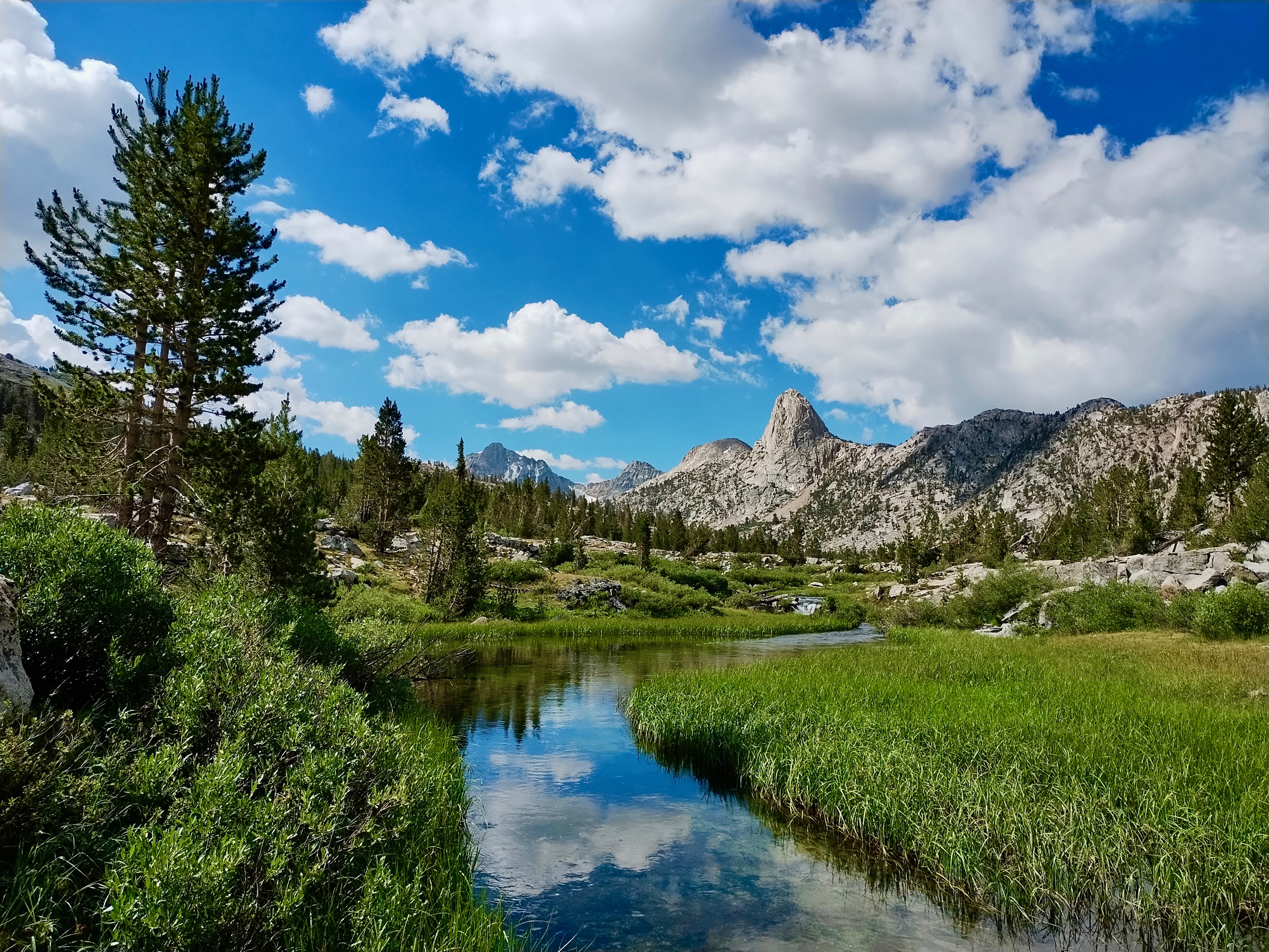
| Rae Lakes and Fin Dome |
 |
| Woods Creek with Fin Dome in the background |
Day 3, Tuesday July 16: Paradise Valley to Roads End (10 miles)
I wake up in the dawn glow, enjoy my quick morning ritual, and then start descending Paradise Valley along the South Fork of the Kings. At many points, the trail opens up to views down the steep gorge. I arrive at Roads End by about 10am, very glad that I honored the urge to exit the wilderness. At the trailhead I am greeted by park ranger Barry, who seems genuinely glad to see me return and tells me that the snakes I saw were king snakes, not coral snakes. On the drive out, I stop at a turnout along Highway 180 and take in impressive views of Kings Canyon. Just before Fresno, I eat lunch at Chipotle, fill up on bubble water (pro tip for the bubble water fans: every Chipotle has a “soda” lever on their fountain drink stations), and then enjoy the rest of In the Dark Season 2 on my way back to San Gregorio.
 |
| South Fork of the Kings |
 |
| South Fork of the Kings (from Highway 180) |
A Song of the Solstice: (from June)
I see winter rains falling on the summer grass, waist-high and browning
I hear the rushing of the creek on the crest of the hill
I feel the heat of the sun in the shade of the valley
I greet the intensity of day with knowledge of night
The mission of man moves with mad momentum, shifting, chaotic
A storm churning like waves in a high mountain hollow
Aligning briefly with my direction, inertial and slow, before rushing onward in endless pursuit
I am left again with the rocks and the trees, the cedar and the cypress
I set myself adrift in the currents of time
Synchronize my breath with the rhythms of tectonic forces
Tap into the power of the rippling earth
Float, unknowing, in the cycle and the flow
See the sun rise and the moon set with no eyes for tomorrow
Feel the intensity of the day with no fear of night
I am the rocks and the trees, the cedar and the cypress